.jpg)


RADIO NAVIGATION
There are numerous radio navigation systems available—Loran, Omega, RNAV, GPS—but the most commonly conventional are Very High Frequency Omnidirectional Range (VOR) and Automatic Direction Finder (ADF).
VOR
VORs transmit between 108 to 117.95 MHz. On the ground, the transmitter looks like a Gemini space capsule.
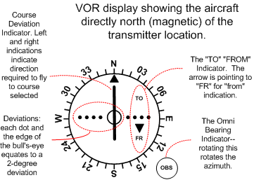
The VOR receiver in the cockpit incorporates three functions: (1) the Omni Bearing Selector (OBS) which appears as a rotating azimuth dial which provides for bearing selection; (2) the Course Deviation Indicator (CDI), which is a vertical needle that moves laterally along a row of dots, each dot representing two degrees; the CDI can be centred by rotating the OBS; when this is done the aircraft position on one of the VOR radials is indicated; (3) the TO/FROM Indicator informs whether the aircraft bearing is “to” or “from” the VOR.
Before using a VOR, the instrument must be tuned and identified; to confirm the identity of the VOR, the “indent” function is turned on (much like a VHF radio) and the VOR identifier (three letters) is transmitted in Morse Code, which the pilot can read from his chart.
VOR receivers sometimes have internal testing capability; but major airports provide VOT equipment (VOR Testing), in which the VOT frequency is selected and the equipment tested.
A variation from VOR transmitters is VORTAC, which combines VOR functioning with DME (Distance Measuring Equipment). A military variation is TACAN (Tactical Air Navigation) which requires Ultra High Frequency Equipment (UHF) and is not commonly used by General Aviation.
VORs are limited in that they transmit line of sight—as is the case with all VHF radio transmission. Accordingly, the lower you fly, the closer you must be to pick up a signal; as a rule, 1.23 times the square root of your altitude gives you the nautical range of a VOR.
The concept of a radial can be somewhat confusing. What has to be remembered is that there are 360 radials radiating from the VOR. If you are in reception range, and you have selected the proper frequency, the turning of the OBS will eventually centre the CDI (needle) with a FROM indication (arrow pointing downward)—when this is done the radial that the aircraft is on is indicated at the top of the azimuth.
What you have to be aware of, however, is that the rotation of the OBS 360° will in fact centre the needle twice, the first as just mention with a FROM indication (indicating the present radial), but also a second time with a TO indication. This feature—CDI centred with a TO indication—allows the pilot to determine instantaneously the course required to proceed directly to the VOR. To provide an example, note that both indications show that the aircraft is directly west of a VOR transmitter:
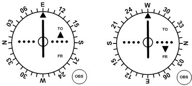
In the left display, the rotation of the OBS to 090° (at the top) has produced a centred CDI with a TO indication—essentially, the VOR is saying (if it could speak) fly 090° to proceed to the VOR. The aircraft must be to the west of the station. In the right display, with the aircraft in the exact same geographic position, the selection of 270° (using the OBS) has produced a centred CDI with a FROM indication—the VOR, in this case, is saying: fly 270° to proceed direct from the VOR. The radial the aircraft is currently on is only directly read from the right display, because it has a FROM indication. The present radial can also be discerned from the left display, but it has to be read at the bottom of the azimuth.
As you can see, the VOR information has nothing to do with the heading of the aircraft. It doesn’t know which way you have the thing pointed. To make sure you don’t get confused, it is always a good case to orient the aircraft in the same course as has been selected on the OBS. When this is done, all the directions make sense.
Another way to learn how to interpret information on the VOR display is to look at the four quadrants of a VOR. In the example below, the pilot has selected the 030° Radial—this appears at the top of the display. Note the various indications based on the quadrant the aircraft is located. To make comprehension easier, the aircraft depicted have been oriented to match the OBS selection of 030°.
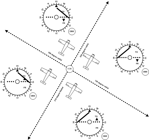
In the upper left quadrant, the CDI is deflecting right, indicating to the pilot that the aircraft is to the left of course. To intercept the selected 030° Radial, the aircraft must be flown in the direction of the needle, but this only works if the aircraft is oriented to the OBS selection. Note the FROM indication, showing that the aircraft is to the north east of the 90° off-setting radials—a line combining the 300° and 120° Radials. In the upper right quadrant, everything is the same as the upper-left except the needle is deflecting left.
Here (upper right quadrant) the pilot must fly left to intercept the selected 030° Radial.
Note that in the lower two quadrants the TO indication is displayed. Relative to the OBS setting, this tells that the VOR transmitter is in front of the aircraft. The reverse is the same for the upper quadrants, except the pilot is advised the VOR lies behind the oriented aircraft.
The following is a summary of basic VOR procedures:
- To “home” to a VOR transmitter:
- tune and identify;
- centre the CDI with OBS that provides a “to” indication;
- fly a heading to maintain the track—if the CDI migrates left, you are to the right of track; if the CDI migrates right, you are to the left of track.
- To intercept a pre-determined VOR course:
- tune and identify;
- select the track desired using the OBS;
- orient the aircraft to the same heading;
- insure that a “to” indication appears (if “from” appears, you are on the wrong side of the VOR);
- if the CDI is on the right of centre, add the desired intercept angle to the current orientated heading and fly the intercept; if the CDI is on the left, subtract the desired intercept angle;
- when the CDI centres during the intercept, alter course to maintain the desired track.
- To track outbound, the same process is used, except you ensure a “from” indication is indicated.
Note the depiction on aeronautical charts of commonly used routings between VORs or VORTACs. Referred to as victor airways , they appear as thin blue lines between transmitters, and are commonly used by en route air traffic. Victor airways are identified by a number system similar to highways; those assigned an odd number are generally north-south routes, while even numbered airways are east-west.
ADF
ADF (Automatic Direction Finder) is the equipment in the aircraft that is designed to pick up radio navigation signals from Non-directional Beacons (NDBs). NDBs operate on low frequencies—200 KHz to 1750 KHz. This is the same frequency range used by commercial AM station broadcasts, which means that these can be picked up by the ADF equipment as well.
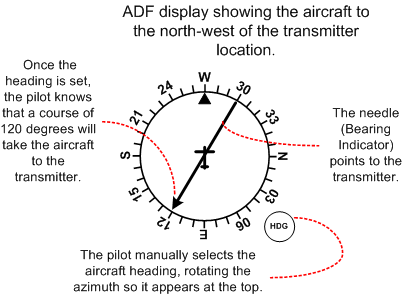
ADF provides a “homing” function—that is, the needle in the ADF cockpit receiver points to the station (Bearing Indicator). Again, the receiver must be tuned and identified before use.
The advantage of ADF is that it is not limited to “line of sight” and is therefore effective for low-level navigation. The reason is that low frequencies produce both ground and sky waves—transmission energy that bounces off the ground and the ionosphere.
The ADF, however, is subject to some inaccuracies:
- Quadrantal Error, whereby the signal is bent by aircraft metal; quadrantal effect is minimal at the cardinal points (nose, tail and wing tips), and greater in the intermediate bearings;
- Needle Oscillation, whereby the needle oscillates in conditions of static (rainfall and thunderstorms) and weak transmissions;
- Night Effect—the needle relies on the ionosphere reflection at night and becomes more inaccurate;
- Terrain Effect, whereby the direction of radio waves is altered when passing between water and land, especially if the waves intercept the shore line at 30° or more;
- Mountain Effect, whereby signals are altered as they reflect off mountains; and
- Ore Deposits, which cause deflections.
GPS
GPS (Global Positioning System) is perceived by ICAO as the navigation system of the 21st Century. Developed by the US military, the system became operational for civil use in 1994, and now provides amazingly accurate navigation information to within only a few meters in space.

The system utilizes a network of 25 satellites orbiting 10,900 NM above the earth’s surface.1 The system is based on the measurement of distances between the airborne receiver and satellites, thereby establishing position information based on triangulation. Precise calculation of distances is made possible by atomic clocks carried on each satellite, and distance is derived from measuring the time required for a satellite signal to reach the airborne receiver.
While only three satellites would be theoretically needed to determine a position based on triangulation, accuracy would be diminished by potential inaccuracies in the atomic clocks of any one of the three satellites. To compensate for possible time errors, four satellite signals are used and four satellites is considered the minimum number of satellites required for a reliably accurate position fix.
Navigation information is provided by way of waypoints. Waypoints can be airports, intersections published on aeronautical charts, and traditional ground-based navigation transmitter locations. All waypoints are stored in the GPS by way of a data card provided by the manufacturer. The data cards are periodically updated and usually a subscription must be purchased. All GPS systems have facility for “user defined” waypoints.
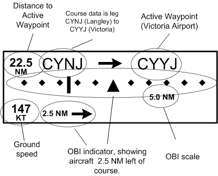
Information regarding the aircraft’s position relative to a waypoint is commonly presented by way of a moving map displayed on the GPS display screen. Distance in nautical miles is simultaneously displayed, and the pilot can select additional data such as groundspeed and estimated time en route to the waypoint. Systems also display track information in the traditional OBI display similar to those used with VORs. The dots on either side of the display are no longer “degrees,” as is the case with VOR displays, but instead are distance. The distance between dots can be altered by the pilot, but it is common for one-dot deflection to equate to 1 NM.
Typically, GPS operates in two modes, the first being LEG mode, and the second being OBS mode. In LEG mode, the GPS will automatically cycle through a series of waypoints that are stored as a sequence in an electronic flight plan. Information display—distance, time, and speed—is always provided for the “next” waypoint in the sequence. If three waypoints are stored, for example—A,B, and C—the data pertaining to waypoint C will be displayed immediately after B is passed. In OBS mode the GPS will not cycle between waypoints, but will instead lock onto one waypoint, giving position information much like that of a traditional VOR—including TO and FROM indications.
References
1 The GPS system is composed of three segments: the Space Segment, the Control Segment, and the User Segment. The Space Segment is composed of the 24 NAVSTAR satellites that orbit the earth. The satellite orbits are precisely planned so that the entire surface of the earth may use the GPS system 24 hours per day, every day. There are almost always more than six satellites in view from every location on Earth. The Control Segment consists of a network of ground-based monitoring and control stations, with the Master Control Station located in Colorado Springs. The satellite data is collected by other ground stations, but is assimilated and analyzed in Colorado Springs. The Master Control Station has facility for the “uplinks” required, for example, to make system clock corrections. The User Segment includes pilots with GPS.