.jpg)


IFR RULES AND PROCEDURES—GENERAL
- IFR RULES AND PROCEDURES—GENERAL
IFR Clearances
All IFR traffic in controlled airspace must conform to routings and altitudes determined by ATC. In essence, ATC maintains the big picture concerning the proximity of “blind” aircraft within specified jurisdictions—e.g., Control Zones, Terminal Control Areas, sectors, etc. Through the issue of clearances to individual aircraft, ATC maintains “separation” between IFR aircraft.1
Jurisdiction
IFR clearances issued by a controller only apply to controlled airspace. Controllers do not have jurisdiction over IFR flights outside controlled airspace—including arrivals and departures from airports located in uncontrolled airports. Conversely, IFR pilots cannot operate in controlled airspace—any Class of controlled airspace—unless they have a clearance to do so. IFR pilots are unrestricted in uncontrolled airspace, but of course there is no separation assurance.
The Contract
IFR clearances in controlled airspace are perhaps best viewed as a contractual agreement—the controller assures safe traffic and terrain separation provided IFR pilots comply with the terms of a clearance. The controller’s ability to maintain a safe IFR environment is dependent upon pilot compliance and adherence.
Verbalisation
All IFR clearances are communicated verbally between controllers and pilots. Even those clearances that appear in a written format—such as appear on the right—must be verbally assigned by the controller and accepted by the pilot.
Impromptu
A great portion of clearances issued and received are impromptu in nature—i.e., they are assigned by controllers in response to specific circumstances and situations related to air traffic—the controller’s “plot”—at a given time. Since the plot is always changing with time, circumstances and situations faced by controllers are always changing. The controller must mitigate the needs of individual pilots with the collective needs of others sharing the same airspace.
Dynamic
From the perspective of a pilot conducting an IFR flight, clearances must be viewed as something that is dynamic rather than static. By this it is meant that clearance content is regularly changed or modified during the course of a flight. It is a paramount rule for all IFR that the last clearance received and acknowledged by the pilot supersedes all related items received in previous clearances. While a pilot may submit a flight plan that contains what appears as a static plan of action, based on proposed routings and altitudes, the actual routings and altitudes that are flown during the actual flight will be changed and modified by successive clearances throughout the flight. IFR pilots must therefore be adaptive and flexible.
Choreography
At its best, IFR clearances are a wonderful choreography involving pilot-controller co-ordination. The process of sending and receiving clearances and clearance requests contains a combination of predictable patterns and routines, on the one hand, and improvised teamwork, on the other. When the exchange of clearances is done well by those involved, it is fluid and efficient; when the exchange isn’t done so well, it can become cumbersome and often inefficiency. Interfacing smoothly with a controller is important and something that is developed with experience.
Efficiency
The exchange of clearances varies with the density of traffic. When IFR traffic is dense—lots of IFR in the controller’s plot—the pattern of pilot-controller communication must become efficient and economical if it is to be effective. Pilot must recognise variations in controller workload and adapt their radio communication accordingly.
The Master Clearance
It is useful to regard IFR clearances as falling into one of two categories. On the one hand, each IFR flight must have what may be referred to as a master clearance. Essentially, the master clearance specifies the overall routing, altitudes, and or procedures that essentially govern the entire flight. It is the big picture or the overall plan of action for the flight that spans the departure, en route, and arrival phases of the flight. The master clearance provides guidance to the pilot in the event that all communication with ATC is lost—both the pilot and ATC maintain a written record of the master clearance, and the flight is expected to be executed by the pilot in accordance with the master clearance should a communication failure occur. For this reason, the master clearance is the first clearance issued by ATC at the beginning of a flight, which, prior to takeoff, establishes the planned or expected routings, altitudes, and procedures that are to be anticipated. The master clearances are sometimes modified during a flight.
On the other hand, there are, during the course of the flight, a series of what are perhaps best described as sub-clearances. Sub-clearances lead to temporary or brief divergence from the master plan, but they do not amend or modify the master clearance content. Receiving radar vectors and altitude assignments during a departure climb, for example, are sub-clearances. The departures heading vectors and altitude assignments are temporary clearance, and the pilot will eventually be cleared to intercept and resume the routing and altitudes specified in the master clearance.
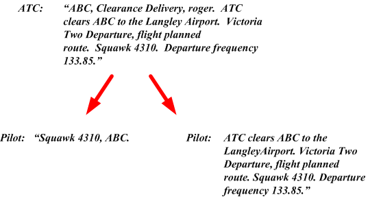
As was mentioned, a master clearance for an IFR flight is established by the controller and the pilot prior to an IFR departure. Specifically, the master clearance is almost always communicated in the first radio exchange between the pilot and a controller. Consider, for example, a pilot who files an IFR flight plan from Vancouver to Calgary. The pilot, we shall say, has file V304 at 15000’. When contact is first made with ATC prior to the IFR departure from a controlled airport—in the case of Vancouver Airport, this contact is with the Clearance Delivery controller—the pilot must report the destination airport and the flight plan altitude. This first communication might therefore go as follows:
“Vancouver Clearance Delivery, this is ABC at Apron 2 with Information Echo. IFR Calgary, 13000.”
Essentially, the pilot is requesting the master clearance for the flight based on the flight plan that has been submitted. In response, ATC—via Clearance Delivery—will confirm the routing as filed, or will provide a modified routing. In either case, the response of ATC, when accepted by the pilot, will become the master clearance that will govern the flight to Calgary. Here are some sample responses that ATC could provide:
|
“ATC clears ABC to the CalgaryAirport as filed.”2 |
The flight plan submitted by the pilot is approved by ATC in its entirety. The routing submitted by the pilot—V304 at 15000’—now becomes the agreed upon master clearance. Should the pilot have a communication failure at the precise moment of takeoff, the pilot and ATC know that this routing will be flown to Calgary Airport. |
|
|
“ATC clears ABC to the CalgaryAirport. Richmond 6 Departure, flight plan route.” |
The flight plan submitted by the pilot is approved as filed, but ATC has added a Standard Instrument Departure—the Richmond 6 Departure.3 |
|
|
“ATC clears ABC to the CalgaryAirport. Richmond 6 Departure, V300, Princeton, Victor 302 Enderby, flight plan route. Maintain 15000.” |
ATC has partially modified the routing of the pilot’s flight plan. Instead of proceeding to Calgary via V304, ATC has cleared the pilot to intercept V300 to the Princeton VOR, and then V302 to the Enderby VOR. From Enderby VOR to the Calgary Airport, the routing is the same as filed by the pilot—i.e., V304. The altitude is as filed by the pilot. |
|
|
“ATC clears ABC to the CalgaryAirport. Richmond 9 departure, V300, Cranbrook VOR, V112. Maintain 17000.” |
ATC has provided a master clearance that is totally modified from the routing flight planned by the pilot.4 |
Master Clearance Modifications and Changes
En route modifications or changes to the master clearance can occur any time after departure. Changes can originate from either the pilot or ATC:
|
Pilot: |
“ABC requesting direct Calgary VORTAC. |
|
|
ATC: |
“ABC, cleared direct Calgary VORTAC.” |
|
|
Pilot: |
“Cleared direct Calgary VORTAC, ABC.” |
|
|
or |
||
|
ATC: |
“ABC, cleared direct Calgary VORTAC.” |
|
|
Pilot: |
“Cleared direct Calgary VORTAC, ABC.” |
|
Major modifications can occur, whereby routing is revised in detail:
|
ATC: |
“ABC, Vancouver Centre, I have changes to your routing. Advise ready to copy.” |
|
Pilot: |
“Go ahead, ABC.” |
|
ATC: |
“ABC is now cleared V300 Princeton, V342 Cranbrook, V305 Calgary.” |
|
Pilot: |
“Cleared V300 Princeton, V342 Cranbrook, V305 Calgary.” |
|
ATC: |
“ABC, read-back correct.” |
Sub-clearances
While the master clearance provides the overall ATC-approved plan for a flight, the pilot will receive during the course of a flight a series of sub-clearance that do not modify a master clearance, but are instead provided as a temporary change in the routing, usually to facilitate safe separation. Here are some examples:
|
“ABC, vectors for traffic. Turn left, heading 040.” |
A sub-clearance of this nature is common during a departure from airport with terminal radar facilities; the controller is modifying routing of traffic for separation purposes. The pilot is temporarily taken off the normal navigation route established in the master plan. When the controller is ready to turn the aircraft back on course, the pilot will receive a clearance similar to the following: “ABC, turn right 120 degrees. Intercept V300 on course.” |
|
“ABC, climb to maintain 14000. Cross Stave Intersection at or above 9000.” |
Again, this clearance relates to the controller’s need to maintain separation during a departure. Presumably there is converging traffic and the controller requires that the pilot be at or above 9000’ by the time a specified fix is reached. |
|
“ABC, maintain 9000 for now, expect 17000 at Stave.” |
Once again, this clearance reflects the controller’s need to maintain separation from converging traffic. The expectation for a higher altitude is likely provided because 9000’ will not meet MEA requirements past Stave Intersection, and the pilot will know to climb to 11000 prior to passing Stave should a communication failure occur. Note that the master clearance remains valid—if a communication failure occurs, the pilot will resort to the routing and altitudes specified in the master clearance. |
|
“ABC, I have a hold clearance when your ready to copy . . .” |
A hold clearance at an en route fix could be issued by ATC as a result of delays. While arrival at the destination will be delayed, the routing in the master clearance is not affected. |
Clearance Limit
All clearances have what is referred to a clearance limit—by definition, the point to which an aircraft is granted an ATC clearance. Clearance limits always exist in master clearances, but they occasionally appear in sub-clearances. In the master clearance the clearance limit is the destination airport; when a clearance limit is provided in a sub-clearance—a hold clearance, for example—the pilot is always advised of a time at which the pilot should live the sub-clearance limit and continue on with the master clearance to the destination airport.
In the event that a pilot reaches a clearance limit and a further clearance is not received, the pilot should begin a hold procedure at the clearance limit and requires further clearance.
The responsibility rests with the pilot to determine whether or not a received clearance can be complied with in the event of a communications failure. Under such circumstances, a clearance may be refused, but such refusal should specify acceptable alternatives. (AIM, RAC 8.10)
Clearance limits are always associated with hold clearance. The pilot flying from Vancouver to Calgary, for example, might receive a hold clearance as follows:
|
ATC: |
“ABC, hold clearance when you are ready to copy. |
|
Pilot: |
“Go ahead for ABC.” |
|
ATC: |
“ABC is cleared to the Turny Intersection to hold southwest, inbound on Victor 305. Maintain 11000. Expect further clearance at 2015.” |
|
Pilot: |
“Cleared to the Turny Intersection to hold southwest, inbound on Victor 305. Maintain 11000. Expect further clearance at 2015. ABC” |
References
1 The vertical separation of aircraft that ATC must maintain is 1000’ at and below FL290, and 2000’ above Fl290. Lateral separation varies with the phase of flight and ATC communication and radar equipment, and can be based on time, distance, or specified areas based on the type of manoeuvres being flown, referred to as “airspace to be protected” (AIP RAC 6.4). Within a terminal control environment, lateral separation can be as low as 3 NM.
2 For reasons of clarity, routine items normally associated with a departure clearance—e.g., squawk code and assigned initial frequencies—are not included in the examples.
3 The Richmond Six Departure (SID) will be specified on a Vancouver Airport departure plate in Canada Air Pilot.
4 While this is rare, it sometimes happens, and creates quite a bit of improvised work on the part of the pilot.
Clearance Rules
An ATC clearance therefore consists of three elements—altitude, routing, and a limit. The altitude and routing is readily apparent—“ABC, climb present heading. Maintain 4000. Through 3000, cleared to the Victoria VOR via direct.” 1
Read-backs
IFR clearances must always be read back. The idea, of course, is that this will prevent misinterpretation. The best policy is to repeat the clearance text back to the controller verbatim, adding the aircraft identification. Thus with respect to the above clearance, the verbatim read-back would be as follows: “Climb present heading. Maintain 4000. Through 3000, cleared to the Victoria VOR via direct, ABC.”
The one exception to the read-back rule pertains to departure clearances containing reference to a Standard Instrument Departure (SID). When such a clearance is provided, the pilot need only repeat the aircraft call sign and the assigned transponder code. If there is a perceived need for clarity, the pilot may respond with a full read-back, or the controller may request this. Here at the two possible read-backs to a departure clearance containing a SID:
Conformity and Compliance
Remember that the pilot must comply with a clearance once it is acknowledged; if a clearance is not acceptable, the pilot must immediately notify ATC.
Pilots must always comply and conform with a clearance, the one exception to this being emergencies. If the pilot does deviate for this reason, the emergency must be such that immediate deviation is required; otherwise, the pilot must immediately advise ATC of the emergency status before a deviation takes place.
IFR in VMC
An IFR clearance only provides separation between IFR traffic. Therefore, in VMC conditions, IFR pilots must provide their own separation from VFR traffic.
IFR clearances can include VFR component—e.g., to depart, climb, or descend VFR—but this can only be provided by ATC if the pilot requests it and weather conditions permit it. Such clearances cannot be provided in Class A or B airspace.
When a pilot requests a VFR departure without an IFR clearance, ATC approval will include instructions on when and where the pilot is to contact ATC for the IFR clearance.
Emergencies and Communication Failures
ATC is authorised to provide all sorts of extra assistance in the event of an emergency, but the pilot must first clearly communicate that an emergency exists.
Keep in mind that the Code 7700 is only detectable in SSR2 Radar areas.

The rules with respect to communication failure procedures are governed by the general provision of “good judgement”—that is, pilots are expected to exercise good judgement in response to the reality that all circumstances that a pilot might be faced with cannot be covered by regulation.3
The general rules and procedures for communication failures outlined below may be superseded by specific procedures contained, for example, in a Standard Instrument Departure .
Communications Failure—General Requirements
Generally, the pilot shall, when faced with a communications failure in controlled airspace in IFR condition, or when operating in Class B or C airspace in VFR:
-
- selected Code 7600;
- maintain a listening watch on appropriate frequencies and acknowledge such messages by any available means (including selective use of normal/standby transponder functions);
- attempt to contact any ATC facility;
- comply with CAP/JEP and CFS provisions;
- attempt to contact ATC by a cellular telephone.
Communications Failure in VMC
If on an IFR Flight Plan in VFR weather, or if VFR conditions are encountered after a communications failure occurrence, the pilot shall land as soon as practicable.
The interpretation of “as soon as practicable” is applied here in that extended IFR operation in controlled airspace in VFR weather is to be avoided. However, “as soon as practicable” does not imply “as soon as possible” in that the pilots retain the prerogative of exercising “good judgement” and is therefore not required to land at an unauthorised airport, an airport that is unsuitable, or a different airport only minutes short of the destination airport.
Communications Failure in IMC
If the communications failure occurs in IMC or the VMC provisions above cannot be complied with the pilot shall
- With respect to routing,
- by the last routing assigned by ATC and acknowledged by the pilot;
- in the event of radar vectors, by the direct route from the point of communications failure to the fix, route, or airway specified in a vector clearance;
- in the absence of an ATC assigned route, by the by the route ATC has indicated may be expected in a further clearance; or,
- in the absence of an assigned or expected route, the routing set out in the filed flight plan.
- With respect to altitude, the highest of the following altitudes for the route segment being flown:
- the altitude last assigned by ATC and acknowledged by the pilot;
- the minimum IFR altitude;
- the altitude that ATC has advised may be expected (and the climb to this expected altitude shall be initiated at the time of specified ATC).
Special Notes:
The intention of these altitude provisions is to ensure obstacle clearance.
If the communications failure occurs during vectoring at a vectoring altitude that is lower than the published minimum IFR altitude, the pilot shall immediately climb and maintain the published minimum IFR altitude until arrival at the fix, route or airway specified in the IFR clearance.
- With respect to approach descents, maintain the en route altitude to the navigation facility or approach fix to be used for the instrument approach, and begin the appropriate descent procedure at whichever of the following times is the most recent:
- the estimated ETA (from takeoff time plus the filed or amended time en route);
- the ETA last notified to and acknowledged by ATC, or
- the expected approach time last received and acknowledged.
Special Notes:
If holding at a non-approach fix, the pilot should leave the fix at the “expect further clearance” time and proceed to a fix at which an approach begins, and begin the descent for an approach as close as possible to the ETA as specified above.1
If a non-RNAV STAR or profile descent clearance has been received, the pilot shall maintain the altitudes specified above and proceed to the final approach fix via:
-
- the published routings, or
- the published routing to the segment where radar vectors are shown to commence, and from there direct to the facility or fix serving the assigned or active runway for a straight-in approach if able, or the full procedure where published.
In the event of an RNAV STAR, the pilot conforms to both the routing and altitude requirements depicted on the chart and proceeds from the Downwind Termination Waypoint (DTW) to the Final Approach Course Fix (FACF) for a straight-in approach.
1 For this reason, a standard component in a hold clearance is the “expect further clearance,” or “expect approach clearance”—“ABC, cleared direct to the Whatcom Vortac. Maintain 4000. Hold south-west, inbound on the 230° Radial. Expect further clearance at 0130Z.”
Communications Failure—Additional Considerations
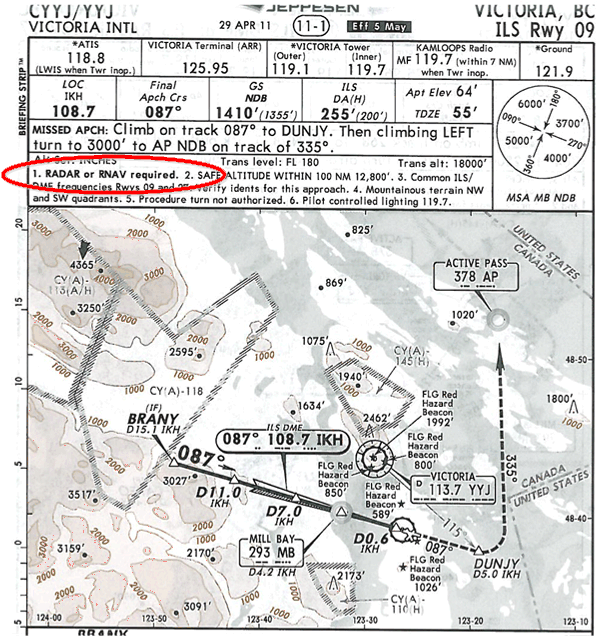
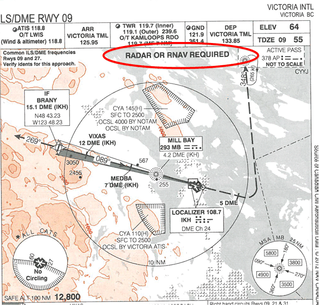
Where “Radar required” is specified on an approach procedure, guidance during the initial approach segment is provided only by ATC. In these cases pilots are encouraged to “dead reckon” to the final approach course and conduct a straight-in approach without unexpected manoeuvring—this is discussed further, below, with respect to Victoria International Airport.
Pilots are encouraged to use cellular telephones and FSS telephone numbers which are published in the CFS.
Communications failure procedures in the U.S. are essentially the same as Canadian procedures.
Communication Failure Scenarios
Remember that, in the event of a communications failure, and provided your transponder is still sending a functional signal, ATC will do all that is necessary to clear the aircraft’s route. This is only possible, however, in a radar environment. In a non-radar environment, time becomes the rule of the day, and airspace will be cleared for you on the basis of your estimated en route and arrival time.
In all cases, never make any course or altitude changes that cannot be anticipated by ATC. If the basic rules governing IFR communication failures are practised—combined with “good judgement”—everything will work successfully according to plan.
The bad news is that electrical failures that are restricted to an aircraft’s radios would in fact be quite rare. A more likely scenario is that the entire nav/com equipment will be unusable, or, even worse, that the aircraft’s entire electrical system is unusable.
In the event of an entire electrical generation system is rendered unusable, remember that you have limited quantity of electrical energy in the battery, and this must therefore be tightly managed. If your aircraft has an alternator, you will likely be provided warning of a systems failure—an enunciator light, for example. In the case of generator-powered aircraft, the generator is more likely to go off line without careful and continuous monitoring of cockpit indicators. Know before flight how generator malfunctions are indicated to the pilot—low voltage light, etc.
Always plan for all-systems failure before an IFR flight. Where is the VFR weather? What are the ceilings for the en route portion?
In the worst case, all-systems failure scenario, you will be in cloud. Initially, you will know your exact position, but as time goes by, your reckoning will become less accurate. If the ceilings provide opportunity for a safe descent into VFR conditions, time management will be critical. If vertical descent from IMC conditions is not possible, then you must consider a lateral exit from IMC conditions. Then your knowledge of how extensive the weather system is becomes crucial—what heading do you fly using your compass to exit laterally from IMC conditions?
En Route Portion
This portion of IFR flight is perhaps the most straightforward—the routing contained in the flight plan, or last amended by ATC or the pilot (communicated and acknowledged) is simply flown.
With respect to any route segment flown, the aircraft must fly at the master clearance altitude, or the MEA, whichever is highest. So as the fixes are approached along the route, the pilot must scan the map to ensure at or above the MEA.
If for any reason the aircraft has been cleared to an altitude that is satisfactory for the current route segment, but unsatisfactory for segments further along the route—i.e., below the MEA of those segments—the pilot should shuttle climb in the hold at the fix located at the start of the segment for which a climb to the MEA is required.
Arrival Portion
Unless a RNAV STAR has been filed or assigned, the en route altitude must be maintained to the final approach fix for a selected approach at the destination airport (an RNAV STAR requires conformity to depicted attitude requirements).
Langley Departure
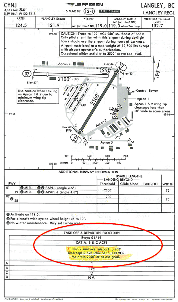
The departure from Langley Airport is unique in that a master clearance is commonly not conveyed to the pilot by ATC prior to takeoff. Owing to the close proximity of Langley to the approach corridors of Vancouver and Abbotsford airport, pilots departing from Langley are simply provided a “no-delay” clearance to the Whatcom VORTAC. Here is an example of a clearance exchange between ATC at Langley Airport (the Ground Controller) and a pilot planning a training flight with Langley Airport as the destination (a round-robin flight):
|
Pilot: |
“Langley Ground, ABC is at Hangar 4B, Information Bravo, IFR Langley, 3000.” |
|
ATC: |
“ABC, Langley Ground, Roger. Taxi . . . . advise when run-up complete and I will put your clearance on request.”5 |
|
Pilot: |
“Ground, ABC has completed the runway.” |
|
ATC: |
“Roger, clearance is on request.” |
|
ATC: |
“ABC, Ground. I have your IFR clearance.” |
|
Pilot: |
“Roger. Go ahead with the clearance.” |
|
ATC: |
“ATC clears ABC to the Whatcom VORTAC via the published departure procedure. Maintain 2000. No delay expected. Squawk 4310. Contact Victoria Terminal on frequency 132.7 when advised.” |
|
Pilot: |
“ATC clears ABC to the Whatcom VORTAC via the published departure procedure. Maintain 2000. No delay expected. Squawk 4310. Contact Victoria Terminal on frequency 132.7 when advised.” |
|
ATC: |
“ABC, read-back correct. Contact Tower on 119.0 when ready.” |
The interesting feature here is that the ATC unit at Langley Airport has not communicated a master clearance to the aircraft. Lacking a verbal master clearance, the pilot must resort to the flight plan that was filed prior to start-up—this now becomes the master clearance for the flight. The cue “no delay expected” is added to the clearance to indicate that the pilot should proceed directly into the routing contained in that flight plan.
A second interesting feature is the assigned altitude—2000’. This conforms with the published departure procedures published in CAP, but the altitude is inadequate beyond the routing—i.e., direct to the Whatcom VORTAC. Should a communications failure occur immediately after takeoff—more specifically, entering cloud immediately after takeoff—the pilot would have to initiate a shuttle climb (in a holding pattern) at Whatcom, and once the en route altitude is attained, proceed with the routing contained in the flight plan.
Once the handoff to Victoria Terminal occurs, the master clearance is typically provided:
|
Pilot: |
“Victoria Terminal, this is ABC off Langley Airport, Runway 19, through 1700' for 2000.” |
|
ATC: |
“ABC, swawk IDENT.” |
|
ATC: |
“ABC, radar Identified. You are now cleared to the Langley Aiport, direct Whatcom VORTAC, Flight Plan Route. Maintain 2000. I have a hold clearance when you are ready to copy.” |
Victoria SID Departure
Let us now examine the communication failure procedures as they apply to an aircraft flying a SID departure—in this case the SID named “Victoria”—i.e., the Victoria SID. At the time of writing, the Victoria SID is properly referred to as the “Vancouver Three Departure” and the number—in this case “Three” will change as the procedure is amended and modified in future CAP/JEP publications. Here is the JEP depiction of this SID:
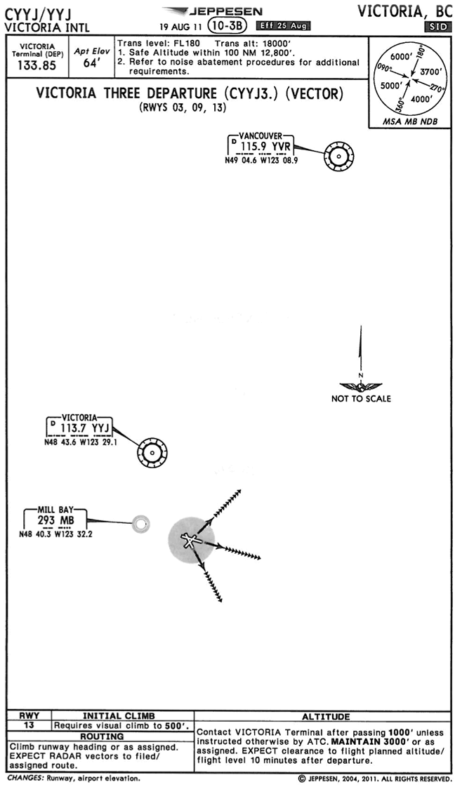
The depiction contains a plan-view showing the Victoria runways, as well as the vicinity airways and navigation aids (fixes). The depiction also contains the written description of the departure elements at the bottom of the plate, including routing and altitude, and in the case of Runway 13, the requirement for visual climb to 500' ASL. It is this written description to which the pilot is expected to conform after takeoff, and of course it is this description that must be briefed by the pilot (for the purpose of comprehension) prior to departure. Note as wellthe altitude description also specified when the departure controlled is to be contacted—Victoria Terminal, after climing through 1000'; with most departure procedures, the frequency switch to departure fequency is specified by the tower controller so as to facilitate operational need.
The description provides for a “vectored” SID—common at larger airports—whereby the pilot normally maintains6 the runway heading until contact with the terminal control unit is made and the aircraft is assigned vectors and altitudes that lead to the “on course”—indicted by the line of arrow heads.
What is important with respect to communication failure procedures is the provision that we are to “expect radar vectors to filed/assigned route or depicted fix and clearance to flight planned altitude/flight level 10 minutes after departure.”
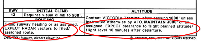
Until the 10 minutes has expired, we are only cleared to maintain 3000’. After this time, we must immediately begin a climb to the assigned or flight plan altitude, and simultaneously turn the aircraft so as to intercept the en route airway—again, the airway either assigned or flight planned.
It is possible that a departure controller holds you below 3000’ for the purpose of safe separation. Since the vectoring altitude is below the published altitude, a pilot experiencing a communication failure who has been held below 3000 should plan to immediately climb and maintain 3000 to wait-out the expiration of the 10 minutes.7
Victoria DUNCN STAR Arrival
What is required in the event that a communication failure occurs to an aircraft, the flight plan for which includes a STAR, or a STAR has been assigned? Below is Jeppesen's depiction of the DUNCN STAR into Victoria International Airport:
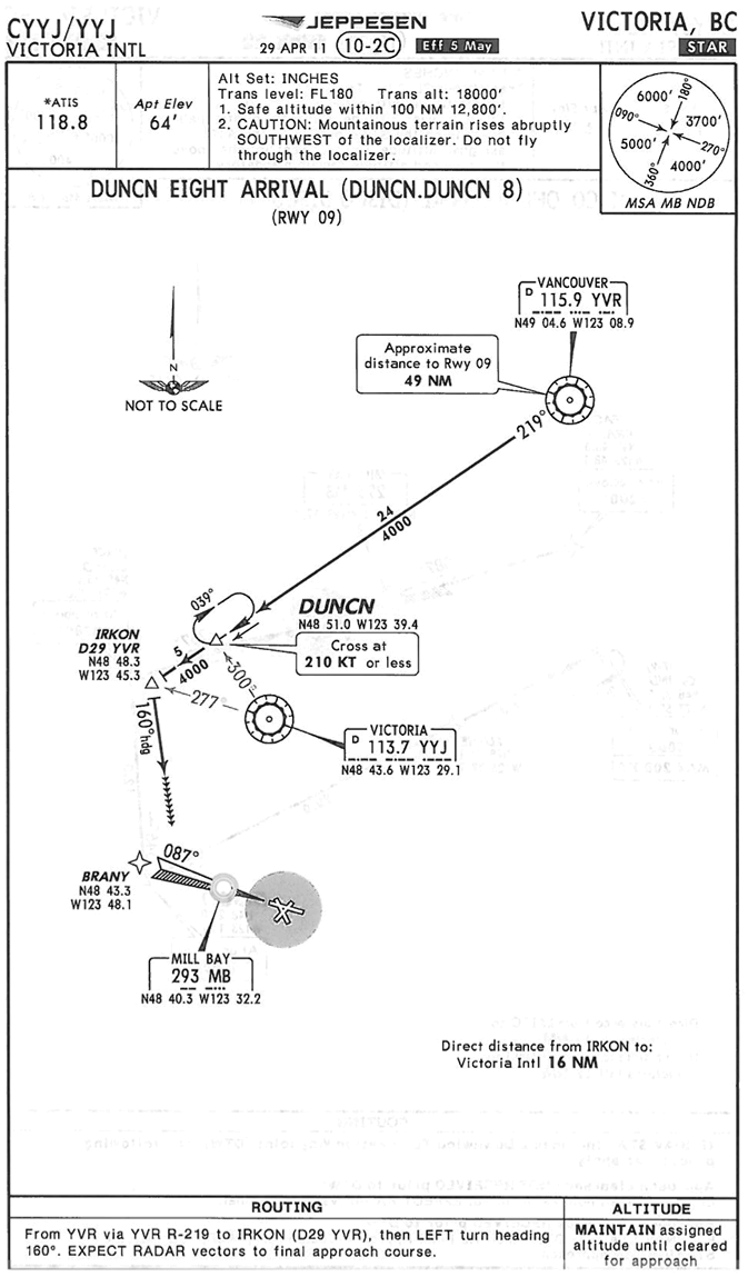
Again, like the SID, we have a plan-view of the DUNCN routing, including the navigation aids used to define the route. We are also given a written description of the clearance at the bottom of the chart, which summaries the routing depicted. To the right of the routing discriptive text, we have the altitude portion of the clearance. Note that since this is a non-RNAV STAR, the altitude to be maintain when a communcation failure occurs is simply the last assigned. Accordingly, we maintain the last assigned altitude and follow the depicted track until we get to the "expect radar vectors" point, as indicated the line of arrow heads that follow the 160° after crossing IRKON intersection. South of IRKON, then, we can begin—in a communication failure—self-navigation for the approach. If we elect to conduct an approach procedure with a published final approach fix, we would proceed directly from the point at which vectors are expected to the final approach fix for that approach for the purpose of conducting a full procedure turn. In the even that the approach we are planning is a “RADAR REQUIRED” approach, then the communication procedure rules require that we dead reckon to the final approach course. The AIM prescribes the following:
Some instrument procedures do not include a procedure turn but include the statement “RADAR OR RNAV REQUIRED” as part of the procedure. The initial approach segment of these instrument procedures is being provided by ATC radar vectors. Without ATC radar vectoring, the instrument procedure may not have a published initial approach segment.
Should an aircraft communications failure occur while the aircraft is being vectored on one of these approaches, separately or as part of a STAR, the pilot is expected to comply with the communications failure procedure by selecting the transponder to Mode A/3 Code 7600 immediately. Pilots should always be aware of the traffic situation. For example, ATC may have indicated that your aircraft was second for an approach to Runway 06L; under these circumstances, the flight should be continued along the route that normally would have been expected under radar vectoring. In some cases of communications failure, pilots may need to dead reckon, or DR, a route to the final approach course. It is important to other aircraft and ATC for the aircraft experiencing a communications failure to continue the flight along a route that would permit the aircraft to conduct a straight-in approach and landing without unexpected manoeuvring. Pilots are expected to exercise good judgment in these cases. Unexpected manoeuvres, such as turns away from the final approach course, may cause traffic disruptions and conflicts. AIM
What about RNAV STARs? In reality, they are virtually identical, but remember that the pilot experiencing a communications failure must adhere to altitude requirements depicted in the procedure. Consider the DISCO arrival into Victoria:
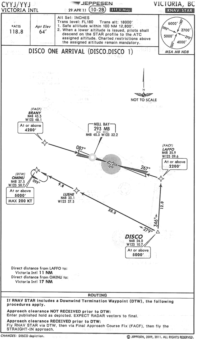
Note the specifications with respect to altitude requirments, which of course becomes mandatory in the case of communications failure, but also look at addional instructions for communciation failure which are presented to the pilot as "expected clearances". What is further interesting in the case of the DISCO Arrival is the fact that this RNAV STAR leads to approach procedures for a runway where procedure turns are not authorized—the pilot, accordingly, is expected to self-navigate to the final approach course, and looking a the plate, the heading to fly looks to be about a 350° MH.
Vectored Approach
There are two important things to remember about communication failure procedures during a vectoring procedure. Firstly, the controller can put you below the published minimum altitudes you would normally fly—e.g., a published Minimum Sector Altitude (MSA) (see P. 140) or a procedure-turn altitude (see P. 141). The lower vectoring altitude can be provided as the controller knows exactly where you are relative to terrain. If a communication failure should occur, however, you don’t know exactly where you are relative to terrain. The rule, therefore, is to immediately climb to a published minimum altitude should a communication failure occur during vectors.
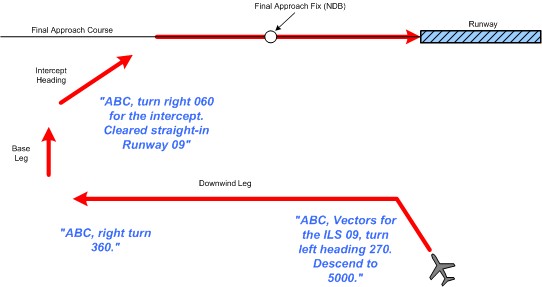
The second important thing to remember about vectored approaches is that the tracking that is followed is almost identical to normal circuit procedures. Normally, but not always, the vectoring includes a down-wind and a base leg. In all cases, however, vectoring ends with an “intercept” heading or leg. When the intercept heading is provided, the pilot simply maintains the heading until the final approach course is intercepted as depicted on the approach plate, whether it be a localizer, NDB track, VOR radial, etc. Should the communication failure occur during vectoring prior to the intercept heading, the pilot must climb to a safe published altitude and proceed to the final approach fix for a full procedure. Should the communication failure occur after the intercept heading, then there should be no change in the altitude or heading and the pilot should simply continue to fly and complete the intercept on the final approach course.
Navigatio-aid Malfunctions
The pilot of an aircraft in IFR flight within controlled airspace shall immediately communicate to ATC any malfunction of navigation or ATC communication.
Instrument Procedures Development
There are two existing standards governing the development and design of instrument procedures—ICAO Standards (PANS-OPS) and U.S. Standards (TERPS). The Canadian standard is outlined in Criteria for the Development of Instrument Procedures (TP 308), which is generally identical to TERPS.
Strict adherence to published instrument procedures will ensure an acceptable level of safety in flight operations.
References:
1 Thus, the pilot holds the present heading until climbing through 3000’. After passing 3000’, the pilot is to continue the climb to 4000’, but track directly to the Victoria VOR.
2 Secondary Surveillance Radar—requires a transponder.
3 Note the meaning here—where there are communication failure procedures (as outlined below), then they must be complied with. Where circumstances of an actual communications failure exist, then “good judgement” must be exercised by the pilot.
4 For this reason, a standard component in a hold clearance is the “expect further clearance,” or “expect approach clearance”—“ABC, cleared direct to the Whatcom Vortac. Maintain 4000. Hold south-west, inbound on the 230° Radial. Expect further clearance at 0130Z.”
5 The practice is that the Langley Tower unit will not contact the terminal control unit and request their approval for the departure until the run-up is completed and the aircraft is only a few minutes away from being ready for takeoff.
6 A departure turn is required off Runway 30 owing to the higher terrain that lies just north of Vancouver Airport.
7 You can imagine that if a controller has held you down below the published altitude during a SID departure is likely doing so for traffic separation reasons—another aircraft is probably above you. Before you initiate a climb from a held-down altitude, be sure you have followed the proper transponder procedures for a communication failure so that other traffic can be moved out of the way.
IFR Flight Plans
It is specified (CAR 602.73) that no pilot-in-command shall operate an aircraft in IFR flight unless an IFR flight plan or IFR flight itinerary has been filed. An IFR pilot may, however, file an IFR flight itinerary instead of an IFR flight plan where
- the flight is conducted in whole or in part outside controlled airspace, 1 or
- facilities are inadequate to permit the communication of a flight plan information to ATS.2
When to file
IFR flight plans or flight itineraries should be filed as early as practicable in or to facilitate ATS entering the flight into the ATS data processing system, preferably at least 30 minutes prior to the proposed departure time. Filing less than 30 minutes could cause delays.
Changes during flight
As soon as practicable, an IFR pilot must notify ATS of any changes with respect to the cruising altitude of a flight, the routing of a flight, and the destination airport. Additionally, when in controlled airspace, the pilot must notify ATS of any change in true airspeed where the change is 5% or more of the true airspeed contained in an IFR flight plan.3
Composite IFR and VFR planning
A composite flight plan or flight itinerary is where portions of the flight are operated under VFR, and part of the flight is operated under IFR. Where IFR governs the first part of the flight, ATC will clear the aircraft to the point within controlled airspace where the IFR portion ends. Where VFR governs the first part of the flight, the pilot is expected to contact ATC for an IFR clearance prior to approaching the point at which the IFR portion begins.
If direct contact with ATC is not possible, a pilot may contact FSS and request the clearance.
Intermediate Stops
These may not be used on an IFR flight plan.
Consecutive IFR flight planning
Consecutive IFR flight plans can be filed, each of which must contain independent information normally required for any flight plan. However, there are conditions—the flights must be in Canada, and the sequence of stops will fall within one 24-hour period.
IFR training flight plans
An IFR training flight plan is defined as a flight where there are no intermediate stops and yet one or more instrument approaches will be conducted en route.
With respect to IFR training flight plans, the following rules apply:
- a single flight plan is filed;
- the en route locations where the practice instrument approach and missed approaches are planned shall be listed in the “Other Information” section of the flight plan, along with the estimated time required to conduct the procedure (i.e., ILS 29 at CYYJ—10 minutes, NDB 07 at CYXX—10 minutes).4
- the estimated time en route is not to include the estimated time required to carry out the approach at the specified locations.5
- ATC will normally clear the aircraft to the final destination.6.
Alternate Airport Requirements
All IFR flights must have a designated “alternate airport” that is suitable for use by the aircraft, and this alternate airport must be indicated in the Flight Plan or Flight Itinerary.
The most important thing to remember about alternates is that they will only be used when the weather is bad. The destination airport has gone below IFR minimums, and you are now relying on your alternate airport to get safely back on the ground. The planned flight has essentially been aborted, and a back-up plan of action is required.
When selecting an alternate, then, you want to make sure it provides a solid and secure means of getting out of the weather. When possible, it should be an airport with a precision approach, and its position should lie between the planned departure and destination airports—as opposed to being located, for example, beyond the planned destination.
Two sets of rules govern the selection of an alternate, the first relates to fuel requirements, and the second relates to forecasted weather requirements.
Alternate Fuel Requirements
The fuel requirements for IFR aircraft establish that the aircraft shall carry an amount of fuel that is sufficient to allow the aircraft to complete the following:
- In the case of a propeller-driven aircraft,
- where the alternate airport is specified in a flight plan or flight itinerary, to fly to the destination airport and execute an approach and a missed approach, and then fly to and land at the alternate airport, and then fly for an additional period of 45 minutes, or
- when an alternate airport is not specified in a flight plan or flight itinerary, to fly to the destination airport and execute an approach and a missed approach, and then to fly for an additional period of 45 minutes.7
- In the case of turbojet powered aircraft,
- where the alternate airport is specified in a flight plan or flight itinerary, to fly to the destination airport and execute an approach and a missed approach, and then fly to and land at the alternate airport, and then fly for an additional period of 30 minutes, or
- when an alternate airport is not specified in a flight plan or flight itinerary, to fly to the destination airport and execute an approach and a missed approach, and then to fly for an additional period of 30 minutes.
Alternate Weather Requirements
The weather for the designated alternate, based on available weather information, must indicate that the ceiling and ground visibility will be, at the expected time of arrival, at or above the alternate airport weather minima criteria.
The following specifies alternate minima:
|
Alternate Weather Minima Requirements Table |
|||
|---|---|---|---|
|
Facilities Available at Suitable Alternate Airport |
Ceiling and Visibility Requirements |
||
|
Two or more usable precision approaches, each providing straight-in minima to separate suitable runways. |
400’ & 1 SM |
or |
200’ and ½ SM above the lowest usable Height Above Touchdown (HAT) and recommended visibility, whichever is greater. |
|
Only one usable precision approach. |
600’ & 2 SM |
or |
300’ and 1 SM above HAT and the lowest recommended visibility, whichever is greater. |
|
Only a non-precision approach. |
800’ & 2 SM |
or |
300’ and 1 SM above HAT/HAA and the lowest recommended visibility, whichever is greater. |
|
No IFR approach available. |
Not less than 500’ above a minimum IFR altitude that will permit a VFR approach and landing. |
||
The correct interpretation of this table is important, and there are a number of points that must be elaborated upon and properly understood.
General Provisions
The selection of applicable minima for an aircraft (i.e., the application of the above table) shall be consistent with the performance of the aircraft used, the navigation equipment on board and the aircraft (and its limitations), the nature of the weather forecasts available, and the airport runway(s) to be used.
GPS Restriction
An airport with only GPS approaches available cannot be used to file as an alternate.8
Precision and Non-precision Approaches
In order to apply the alternate minima requirements, we must first understand the difference between a precision approach, on the one hand, and a non-precision approach, on the other.
Only ILS and PAR approaches qualify as precision approaches.9 They generally have the lowest minima of all published procedures and they allow for the most precise positioning of the aircraft just prior to landing. Precision approaches are the only approach procedures that have a published decision height (DH). The DH is a specified horizontal plan above the runway threshold where the electronic glide path and localizer intercept. The aircraft is in a descending attitude only seconds from touchdown (where visual reference with the runway is made). In contrast, an aircraft reaches the threshold area of runway with far less precision and accuracy with a non-precision approach. Non-precision approaches have minimum descent altitudes (MDAs), rather than DHs, and the aircraft reaches the threshold area in a level attitude. Only when the required visual reference with the runway is established can the pilot initiate the final descent that leads to touchdown. In many cases—i.e., during circling approaches—the pilot must circle the airport area prior to beginning the final descent. In short, non-precision approaches—NDB, VOR, Localizer, GPS are a lot less precise—accordingly, the weather minima required for using an airport with only a non-precision
approach are much higher.
As is evident, the lowest alternate minima are provided only for airports equipped with precision approaches, rather than non-precision approaches. The alternate minima are even lower were the airport is equipped with multiple precision approaches.
Separate Runways
In order to apply the alternate minima requirements above, we must also understand what is meant by the expression two separate suitable runways.
Separate runways means separate runway surfaces. Accordingly, an airport equipped with two precision approaches at either end of one runway surface—Victoria Airport’s Runways 09 and 27, for example—would not qualify. Vancouver Airport, however, would potentially qualify, as there are three runway surfaces, each of which has a precision approach.
Usable Runways
To satisfy the meaning of separate and suitable runways, the runway surface themselves must be usable. If, for example, the forecasted crosswind forecast for the parallel runways at Vancouver Airport exceed the practical limits of an aircraft, then there would not be two separate yet usable precision approaches, and the minimum for two precision approaches could not be used. Similarly, if the crosswinds forecast for the one precision approach runway at Abbotsford are excessive, then the minima applicable for one usable precision approach could not be used. You would in the case of Abbotsford have to use the non-precision minimum based on circling minima (as a circling manoeuvre for the into-wind runways—Runways 01 or 19—would have to be used.
Remember that usability of a runway could be affected by many things including runway contamination owing to snow, runway closure for maintenance, or navigation aid outage. Hence the importance of conducting a full weather and NOTAM check for your alternate airport.
The HAT and the VIS
The use of HAT (Height above Touch-down Zone) and visibility is straightforward. In the case of precision approaches, the HAT is based on the distance from the published DH to the Touchdown Zone Elevation. For non-precision approaches, HAT10 is based on the published Minimum Descend Altitude and its height above the touchdown zone. The visibility requirement for alternate minima are based on the published advisory or recommended visibilities published for each approach.
The Sliding Scale
The last aspect of alternate minima relates to the ability to trade HAT for visibility. That is, the pilot is given latitude in that if good visibility is forecast for the alternate airport, the required HAT value can be reduced. This only occurs, however, if the alternate minima values for the selected airport qualify as standard alternate minima. The standard alternate minima are 600’ and 2 SM, in the case of an airport with one usable precision approach, and 800’ and 2 SM, in the case of an airport with a usable non-precision approach. Here is how it works:
|
Type of Approach Available |
Standard Alternate Minima |
If Standard Alternate Minima exist, the following values may be used: |
|
Ceiling and Visibility |
Ceiling and Visibility |
|
|
One Usable Precision Approach |
600’ AGL and 2 SM |
700’ AGL and 1½ SM or 800’ AGL and 1 SM |
|
One Usable Non-precision Approach |
800’ AGL and 2 SM |
900’ AGL and 1½ SM or 1000’ AGL and 1 SM |
So, if after doing the alternate minima math, you establish that your ceiling and visibility values are standard, you may still use the airport as an alternate even though the forecast visibilities are less than 2 SM. In order to apply the lesser visibilities, however, the forecasted ceilings must be higher than the standard values as indicated above. If, for example, you are evaluating an airport as an alternate and it has forecast visibility of only 1 SM, this can still be filed and used as an alternate provided the ceiling is greater than 1000’. If the same airport has a usable precision approach, the forecasted ceiling can be as low as 800’.
Note the sliding scale provision is not applicable to alternate airports with two separate and usable precision approaches.
Abbotsford as an Alternate
Let us now look at the application of the alternate minima, as they would apply to Abbotsford Airport.
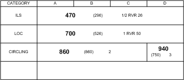
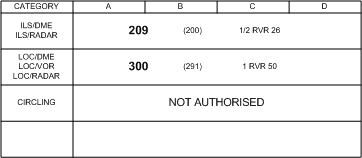
In the first case, let us assume that the ILS approach at Abbotsford is in fact usable. The depiction on the right is based on what appears in the minima box in the lower left-hand corner for the ILS 07.
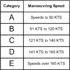
At the top of the minima box are the four aircraft categories.11 Which category your aircraft falls under is based on the airspeed at which your aircraft is going to be manoeuvred when the DH or MDA is reached. Accordingly, this speed will vary depending on the manoeuvre you are flying. The speed at which you conduct a circling manoeuvre (level flight with the gear extended) at the MDA is different from the speed at which you would pass the DH only seconds from touchdown. The speeds and the respective categories are indicated on the right.
Importantly, don’t get the manoeuvring speed for the aircraft category confused with Va—the two, of course, are unrelated.
On the left column of Abbotsford ILS approach (above) are the three approaches for which minima are published for the ILS 07 plate—the ILS, which requires the use of the glideslope and the Localizer, the LOC, which requires the Localizer only, and the CIRCLING, which can be performed off either the ILS or LOC approach.12

To the right of the three approaches are of course the minima. In the case of the ILS approach (above), for example, the DH is 470—an ASL value—while the HAT is 296—an AGL value. To the far right, the recommended visibility is ½ SM, or the equivalent in RVR value—2600’. If we are capable of flying the ILS 07 approach in the event that Abbotsford is filed as the alternate airport—based on aircraft equipment, and forecasted weather for Abbotsford—then it is these minima that we must apply to the alternate minima table above.
The Alternate Math
- Note that when dealing with alternate minima, the concept of “whichever is greater” must be applied. That is, the alternate minimum of standard alternate minima, on the one hand, and the specific alternate minima values applicable for your selected airport. For a selected alternate airport, that is, you have to establish the HAT and VIS specific for the approaches, add the alternate minima values to these, and then compare these values with the so-called standard alternate minima. The alternate minima are 400 and 1 (400-1) for airports with multiple precision approaches, 600 and 2 (600-2) for airports with one precision approach, and 800 and two (800-2) for airports with non-precision approach. These are fixed and never change. To compare these to the specific values for the ILS 07 at Abbotsford, for example, we must take the HAT and the VIS published for this approach and add—since there is only one precision approach at this airport—300 to the HAT and add 1 to the VIS.
- There is one more thing to consider here. Note that the DH or MDA values published for an approach are down to the ten-foot values—470’, and 860’, for example. Alternate minima, however, are dealt with in one-hundred-foot values— 200’, 300’, 400’, etc. Also, forecasted ceilings are published solely in one-hundred-foot values. So we must have some means of rounding-off the published valued. To do this, we have the “20-foot Rule.” According to this rule, a HAT that is published at 420’, for example, is rounded down to 400’, while at HAT value of 421’ or higher is rounded up—e.g. 500’. Accordingly, while a HAT of 212’ becomes 200’ for the purpose of alternate minima calculation, a HAT of 243’ becomes 300’.
- So let us examine the application of the math. Let us say that Abbotsford Airport is proposed as the alternate. The math necessary to determine the applicable minima is as follows:
-
- First, determine the usability of the available runways—i.e., applicable weather, and NOTAMs. If all the approaches are usable, there is only one precision approach and two non-precision approaches (the Localizer and the NDB), but they are published for the same runway surface. We would prefer to use the precision approach in calculating alternate minima, so we have to apply the minima for “one usable precision approach.”
- Secondly, assuming unrestricted usability, calculate the lowest usable HAT and visibility:
- The HAT for the ILS 07 is 296’ and the recommended visibility is ½ SM. For calculation purpose (i.e., the “20-foot rule”), this must be rounded up to 300’.
- We now must add the Abbotsford precision approach HAT and visibility to the 300-1 required for an alternate airport with one usable approach:
|
300’ & ½ SM |
(Abbotsford) |
|
+ 300’ & 1 SM |
(Standard correction value for one precision approach) |
|
= 600’ & 1 ½ SM |
|
-
- Now we must compare the corrected value with the standard alternate minima for an alternate airport with one precision approach—600’ & 2 SM. Which is the higher of the two? The answer is 600’ & 2 SM. Therefore, if we wish to use Abbotsford as our alternate airport, the forecasted weather must be a ceiling not less than 600’ and visibility not less than 2 SM. Is this correct, though? The answer is no. In fact 600’ and 2 SM is standard alternate minima for an airport with one usable precision approach, so we can therefore apply the sliding scale minima that will permit either 700’ and 1½ SM, or 800 and 1 SM. So the forecast visibility for Abbotsford could be as low as 1 SM, but if this is the case we must have a forecast ceiling of not less than 800’.
Vancouver as an Alternate
Lets examine the alternate minima for Vancouver Airport—the only airport in British Columbia with two separate and usable ILS approaches (in fact there are three ILS approaches). We will assume that all precision approaches are usable and suitable (note that straight-in minima must be provided on two or more separate and suitable runway surfaces).
Referring to the format minimum box the ILS approach to Runway 08L, we see the minima box as depicted above. The first thing you will note is that we do not get the conventional “ILS” in the left-hand column. Instead, we get “ILS/DME” and “ILS/RADAR” notation. What these mean is that this approach lacks an NDB for the Final Approach Fix. Instead, DME or ATC radar is used to determine final approach fix crossing.14 If you examine the plate, you will see that the Final Approach Fix is ROSS intersection, and that this can be determined, in the case of the ILS approach, by DME (4 DME)15 or by a Radar Fix,16 or in the case of the LOC approach, by reference to DME, a Radar Fix, or the 300° Radial from the Vancouver VORTAC. Despite these features of the non-NDB Final Approach Fix, the ILS otherwise remains the same as we saw at Abbotsford.17
Here, then, is the alternate minima math for Vancouver. The HAT value here is an even 200’ so we are not required to apply the 20-foot rule. All we do is take the HAT and visibility for this approach—200’ and ½ SM—and add this to the HAT and visibility required for an alternate equipped with two or more usable precision approaches—i.e., 200 & ½ SM:
|
200’ & ½ SM |
(Vancouver) |
||
|
+ 200’ & ½ SM |
(Standard correction value for two or more precision approaches) |
||
|
= 400’ & 1 SM |
|
We now compare this to the 400 & 1 value (as is required in the alternate minima table) and we see that they are the same (there are no higher values to select); therefore the alternate minima to use Vancouver as the alternate is 400’ and 1 SM.
Kamloops as an Alternate
With respect to alternate airports without a precision approach, let us examine Kamloops Airport as the proposed alternate.
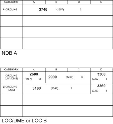
Since exact manoeuvring speed is important in determining the alternate minima values at Kamloops, it will be assumed that the flight is to be done in a light twin. The manoeuvring speed of the aircraft on final approach is 78 KTS (with full flap), and the manoeuvring speed for a circling approach is 91 KTS with 25° flaps.18
Since radio navigation equipment is also important in determining Kamloops minima as an alternate, it will be further assumed that the aircraft is equipped with “standard” radio navigation equipment—VHF, ADF, VOR, and ILS.19 The fact that the aircraft has an ILS is of little value to us since there is not a published ILS for Kamloops.20
The only approaches to select are the LOC DME or the LOC-B, as they appear on one approach plate, or the NDB-A, which appears on a second approach plate. Both plates provide minima for circling approaches, rather than a straight-in approach21). Since a precision approach does not exist for Kamloops, we must apply the alternate minima for an airport equipped with a non-precision approach (800’ and 2 SM, or 300’ and 1 SM above the lowest HAT and associated visibility, whichever is greater).
In assessing alternate minima values, there are three approaches, and therefore three choices. The NDB-A provides a HAT of 2607’, the LOC-B provides a HAT of 2047’, and the LOC/DME-B provides a HAT of 1467’ for Category A aircraft, and 1767’ for Category B aircraft. All HAT are published with a recommended visibility of 3 SM.
As is apparent, to get the lowest minima, we must be able to use the LOC/DME-B minima with the manoeuvring speeds for Category A. Since the manoeuvring speed for Category A can only be achieved by the light twin for a straight-in final approach, selecting the lower minima published for the LOC/DME-B is contingent on being able to use Runway 26. If Runway 26 is not usable—because of forecast winds, for example—the LOC/DME-B could still be used to calculate alternate minima, but the higher Category B values would have to be used—in this case, 2900’.
Assuming that Runway 26 is usable, and that circling is not required, the Category A HAT is 1467’ with 3 SM visibility. Applying the 20-foot rule, this must be rounded up to 1500’. The alternate minima for a non-precision approach are 800’ and 2 SM, or 300’ and 1 SM above the lowest usable HAT:
|
1500’ & 3 SM |
(Kamloops) |
|
+ 300’ & 1 SM |
(Standard correction value for a non-precision approach) |
|
= 1800’ & 4 SM |
|
Obviously, we must select the higher value—in this case 1800’ and 4 SM. This is our minimum weather to use Kamloops as an alternate airport. Because the values are not standard, we cannot apply the sliding scale.
Weather Information for Alternate Airports
There are many additional requirements related to the weather and alternate minima.22
The question arises, for example, regarding the application of the terms BECMG, TEMPO and PROB, as they appear in a TAF, and how they are interpreted relative to alternate minima. The requirements read as follows:
Aerodrome forecasts (TAFs) that contain the terms BECMG, TEMPO or PROB may be used to determine the weather suitability of an aerodrome as an alternate provided that:
-
- where conditions are forecast to improve, the forecast BECMG condition shall be considered to be applicable at the end of the BECMG time period, and these conditions shall not be below the published alternate minima requirements for that aerodrome; and
- where conditions are forecast to deteriorate, the forecast BECMG condition shall be considered to be applicable as the start of the BECMG time period, and these conditions shall not be below the published alternate minima requirements for that aerodrome; and
- the forecast TEMP condition shall not be below the published alternate minima requirements for that aerodrome; and
- the forecast PROB condition shall not be below the appropriate landing minima for that aerodrome.23
Essentially, then, the conditions described in a BECMG and TEMPO part-period shall be interpreted as if the conditions actually exist throughout the times which define the part-period, and they must not be below alternate minima. In the case of PROB part-periods, however, the applicable weather can be below alternate minima, but not below published landing minima for the aerodrome—i.e., the DH or MDA.
The Alternate Weather Minima Requirements Table that appears on P. 96 is “predicated upon the aerodrome having an Aerodrome Forecasts (TAF) available.” What happens when a airport does not have a TAF?
In the event that an aerodrome has a published Aerodrome Advisory,24 it may only qualify for an alternate airport if the forecast ceiling is no lower than 500’ above the lowest usable HAT/HAA, and the visibility is not less than 3 SM.
In the case that an aerodrome, does not have a published TAF or Aerodrome Advisory, it may only qualify for an alternate airport if, based on the Geographic Area Forecast (GFA), the forecast meets the following requirements:
-
- no cloud exists lower than 1000’ above the lowest usable HAT/HAA;
- no cumulonimbus clouds are forecasted;
- the forecast visibility is not less than 3 SM.
Fort Langley as an Alternate
The question arises as to the use of an airport that lacks a published IFR approach and a TAF is not available—as is the case, for example, with Fort Langley. To file Fort Langley as an alternate, we would have to satisfy the requirement that the “forecast weather must be no lower than 500’ above the minimum IFR altitude that would permit a VFR approach and landing.” Fort Langley is of course located in Designated Mountainous Area #5, where the IFR minimum altitude is 2000’ above the highest obstacle with a radius of 5 NM. An examination of the Obstruction Clearance Circle that appears in the Canada Flight Supplement shows the highest obstacle to be 2700’. Therefore the minimum forecast ceiling to file Fort Langley as the alternate is 5200’. Furthermore, the GFA requirements for an alternate airport must also be met. Therefore, the GFA applicable to Fort Langley must provide that no cloud will exist lower than 1000’ HAA, there will be no cumulonimbus clouds, and the visibility will not be less than 3 SM.
Utilizing GPS Approaches at Alternate Airports 25
Initially, GPS approaches could not be used for alternate airport planning, and recently changes in regulations were introduced to changes this an permit their use, but the changes are extremely restrictive so as to make their use largely impractical.
First, a usable approach at the planned destination airport must be served by a functioning traditional navigation aid that is completely independent of GPS—this is regarded as protection against a widespread GPS outage.
Second, only LNAV (lateral GPS navigation) minima figures may be used.
Thirdly, the Pilot-in-command must verify RAIM is available at the planned alternate, including predicted satellite outages (requiring the checking of GPS NOTAMs—see AIM COM 3.16.12.1).
Fourthly, at lease once prior to the mid-point along the flight to the destination airport, the RAIM for the alternate airport must be verfied.
GPS approaches as alternate airport are considered non-precision approaches for the purposes of alternate math.
References
1 The fact that a flight plan is not required in uncontrolled airspace raises the interesting question of whether or not you really want to operate an aircraft where separation is not assured. For the most part, IFR flight in controlled airspace means that someone—an air traffic controller—is employed to ensure separation between aircraft that are flying in cloud. This is not the case in uncontrolled airspace where flying in cloud is something akin to Russian Roulette.
2 In using the expression “ATS,” this should be taken to mean an air traffic control unit, flight service station, or a community aerodrome radio station.
3 The same notification is required if, when using a Mach number, there is a change of .01 or more of the Mach number filed.
4 It is customary—although not written—to include holds in this same format—“hold at HUH—10 minutes.” As you will see in practice, ATC has its own format requirements which often seem to vary with each shift, and you will be left to sort out these “recipe rules” when you start filing training IFR flight plans!
5 Again, in practice, it is common for ATC to want the approach times to be included in the flight plan form ETE.
6 Only the significant rules for IFR training flight have been listed here. For complete details see AIM RAC 3.11.
7 A flight plan or flight itinerary is only required for IFR flight in controlled airspace. There is some confusion here, however, and caution must be used. The way this regulation is written, the non-requirement of a flight plan or fight itinerary would only apply to flights less than 25 NM from the airport of departure. The history of this regulation, however, when an “ATC Flight Itinerary” did not exist and flight itineraries were filed with private responsible persons, was to permit IFR in uncontrolled airspace under a private itinerary. Now the definitions are unclear and somewhat confusing. See flight plan requirements on p. 93 .
8 Based on the table which appears in CAP GEN, Operating Minima—Alternate, p. 1.
9 Where an ILS services a runway, the Touchdown Zone Elevation is published on the procedure plate—hence, there is a HAT. Where a runway lacks ILS service, the elevation of the Touchdown Zone is not measured or published, and instead the HAA is used—Height Above Aerodrome.
10 The main problem with a GPS approach is that satellite coverage cannot be assured (and can cause delays in executing an approach—perhaps three to ten minutes. This would be inconsistent with what could be a critical fuel state when you cannot get into your destination airport and must make the approach at your alternate. To file a GPS-equipped airport as an alternate, you would have to use the alternate minima “no-IFR approach” airport.
11 This is not entirely correct as an MLS approach (Microwave Landing System) is also a precision approach, but they are rare.
12 The HAT is used for runways serviced by an ILS; in the case of runways equipped with a non-precision approach , the expression Height above Aerodrome (HAA) is used. See Footnote #67. In the discussion that follows, reference to HAT implies HAA, where applicable.
13 The categories appear in the CAP GEN, Symbol Legend, Page 4, and also in the AIM, RAC 9.22.
14 On an ILS circling approach, the glidepath and Localizer would be tracked down to the circling minima—860’ in the case of this ILS, and then the aircraft would be levelled at the altitude to circle around the airport for one of the runways. Note on the circling, the aircraft cannot descent below 860’ until the landing is assured.
15 Remember, knowledge of FAF crossing is important for providing a “time to DH” backup, and for confirming that the aircraft is in fact tracking the correct glideslope.
16 4 NM indicated with the DME tuned to IVR (the identifier) on frequency 109.5.
17 When you advise the Arrivals Controller that you are doing a “Radar ILS”, it is their job to then advise you when you cross ROSS intersection—“ABC you are over Ross at this time . . contact the Tower now on 124.0.”
17 The one exception is that the HAT for this Vancouver ILS is quite a bit lower than the HAT for the Abbotsford ILS—owing likely to vicinity obstruction in the approach area of Abbotsford’s Runway 07.
18 These speeds are Piper Seneca speed.
19 In reference to “standard” equipment, I am referring to the “standard COM/NAV equipment” criteria used for the completion of flight plan forms, where the designator “S” is used (see AIM RAC 3.16.4).
20 The fact that the aircraft has an ILS will assure me that the Localiser frequency for Kamloops—109.9 MHz. will be received. This assurance does not exist with some VOR equipment that lack a glideslope.
21 If “circling” did not appear in the left column of the minima box, there would be lower minima values.
22 Based on AIM RAC 3.14.1.
24 An Aerodrome Advisory is a forecast based on observations that are not taken at or near the airport. Advisories are presented in the same format as TAFs. See AIM MET 3.9.1 for additional information.
25 See AIM COM 3.16.12.
Where a descent is required (procedures other than an RNAV STAR, the descent should be made during a holding pattern over the final approach fix—what is referred to as a shuttle descent.