.jpg)


AIRSPACE CLASSIFICATION
The geographic classification of Canadian Airspace is specified in the Designated Airspace Handbook.
Northern and Southern Domestic Airspace
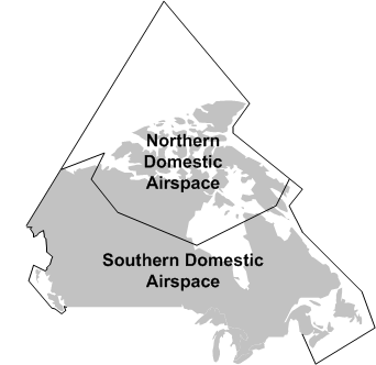
Canadian Airspace is divided into two fundamental areas: Northern Domestic Airspace (NDA) and Southern Domestic Airspace (SDA). The division has a few important rules: While the proper cruising altitude in the SDA is based on magnetic track, cruising altitude in the NDA is based on true track (discussed below). Additionally, runway headings are also based on magnetic track in the SDA, while true track is used in the NDA. Finally, rules for altimeter settings are also based on the SDA/NDA division. Generally, NDA consists of airspace located north of Inuvik, Yellowknife, Churchill, Ivujvik and Iqaluit.
Altimeter Regions
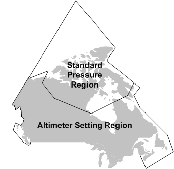
For altimeter use, the Southern Domestic Airspace is referred to as the Altimeter Setting Region where the altimeter must be continually set to the nearest reported altimeter setting.
Here are the rules that apply to the Altimeter Setting Region:
- Before takeoff, the altimeter must be set to the airport reported setting, or, if not available, the airport elevation.
- During flight, it must be set to the setting of the nearest reporting station (Flight Service Station or control tower).
- Prior to landing, it must be set to the destination airport if available.
In contrast, Northern Domestic Airspace is referred to as the Standard Pressure Region, where it is required that the Altimeter be set to 29.92”Hg—known as standard pressure. The exceptions to this is prior to descent for landing and before taking off, when the airport setting (or elevation) must be set. When standard pressure is used by the pilot, he must refer to his altitude as flight level. Accordingly, an altitude of 5500’ ASL, for example, is reported as Flight Level 55, and written as FL055.
More specifically, here are the rules (CAR 602.36) that apply to altimeter practices in the Standard Pressure Region:
- Prior to conducting a departure in the Standard Pressure Region, the pilot shall set the altimeter to the current altimeter setting of the airport.
- Immediately prior to reaching the cruising flight level, the pilot shall set the altimeter to standard pressure; if the cruising flight level is above FL180, the altimeter shall be set to standard pressure immediately after passing through FL180.
- Prior to beginning a descent with the intention to land, the pilot shall set the altimeter to the current altimeter setting of the intended airport.
- When transitioning between the Altimeter Setting Region and the Standard Pressure Region, the change in the altimeter setting shall be made by the pilot while within the Standard Pressure Region, prior to entering, or after leaving, the Altimeter Setting Region.
Flight Information Regions
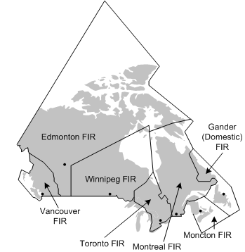
Canadian Airspace is composed of seven Flight Information Regions (FIRs). Their function is to provide flight information and alerting services within their defined boundaries. With respect to IFR flight, however, the immediate role of FIRs is the administration of Area Control Centres. Thus while the Vancouver Area Control Centre oversees all IFR flights in controlled airspace within the Vancouver FIR, Edmonton Control Centre provides the same services for the Edmonton FIR, etc. FIR boundaries are marked on IFR en route charts.
Airspace Classes
Canadian Airspace is further divided into seven classes, each providing individual rules of access, flight regulations, and Air Traffic Control (ATC) responsibility.
The characteristic of the seven classes may be summarised as follows:
Class A
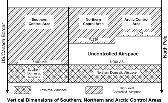
- Class A airspace is defined as all high-level controlled airspace. High-level controlled airspace, in turn, exists from FL180 to FL600 in SDA. In NDA, however, the floor of Class A high-level airspace varies between FL230, in what is referred to as the Northern Control Area, and FL270, in what is referred to as the Arctic Control Areas.
- Only IFR flight is permitted in Class A airspace, and all aircraft are therefore subject to ATC clearances and instructions.
- ATC separation is provided to all aircraft.
- Altimeters are set to 29.92” Hg. (Standard Pressure).
Class B
- Class B airspace is all low-level controlled airspace—low-level controlled airspace is defined as any controlled airspace that exists above 12500’ up to, but not including, FL180.
- Only IFR and Controlled VFR flight is permitted in Class B airspace, and, like Class A airspace, all aircraft are therefore subject to ATC clearances and instructions.
- ATC separation is provided to all aircraft in Class B airspace.
- If an IFR pilot is operating under VFR in Class B airspace and it becomes evident that VMC flight is not possible, the pilot must request an IFR clearance.
- Altimeters are set to local pressure settings.
- Transponders are required with Mode C (altitude encoding) capability.
- Altimeter must have been tested within last 24 months.
- Adequate navigation equipment required for flight planned route.
Class C
- Class C airspace is specifically defined airspace around designated airports described as terminal control areas and associated control zones.
- Controlled airspace whereby both IFR and VFR are permitted to operate, but where VFR aircraft cannot enter until they receive a clearance from ATC.
- ATC provides traffic separation to all aircraft operating IFR, and, as necessary, provides conflict resolution between IFR aircraft and VFR aircraft. ATC conflict-resolution responsibilities are limited to IFR and VFR aircraft that are identified on radar and in communication with ATC.
- While operating in Class C, aircraft must be equipped for two-way radio communication, and the pilot must maintain a continuous listening watch.
- Transponders are required with Mode C (altitude encoding) capability.
- Class C airspace reverts to Class-E status when ATC services are not provided.
Class D
- Class D airspace is specifically defined airspace around designated airports described as terminal control areas and associated control zones.
- Controlled airspace whereby both IFR and VFR are permitted, but where VFR flight must establish two-way communication with an appropriate ATC authority prior to entry.
- ATC provides separation to IFR aircraft. Conflict resolution between IFR and VFR aircraft is provided when equipment and workload permits.
- While operating in Class D, aircraft must be equipped for two-way radio communication, and must maintain a continuous listening watch.
Class E
- Class E airspace is specifically defined airspace normally associated with airways, control area extensions, and transition areas (discussed below); it also exists at designated airports without an operating control tower.
- Controlled airspace in which both IFR and VFR flight may operate; separation is provided to IFR flights, but there are no special requirements for VFR flights.
![]()
- Transition Areas are of defined dimension,1 based at 700’ AGL, and upward to the overlying controlled airspace—it is found at airports where frequent IFR operations occur and are designed to increase separation between IFR and VFR aircraft in poor weather conditions. Essentially, Transition Areas serve the purpose of containing IFR aircraft within controlled airspace.2 Transition Areas normally extend to a 15 NM radius from a designated airport.
- A Control Area Extensions serves the same purpose as Transition Areas (containing IFR aircraft during arrivals and departure procedures)—except they are designed to cover a wider area. They are always based at 2,200’ AGL’ and extend up to but not including 18000’ ASL (unless otherwise indicated).
Class F
- Airspace in which special activities take place, which may or may not restrict air traffic.
- ATC will only clear IFR traffic through Class F airspace if the following conditions3 exist:
- the pilot states that permission to enter the Class F airspace has been obtained from the user agency; or
- ATC clears the aircraft for a visual or contact approach.4
- Class F airspace is specifically described in IFR en route charts, as well as the Designated Airspace Handbook.
- The type of Class F airspace is indicated in the identifier published in charts, of which the following is a typical example: CYA123(T). “CY” indicates that the airspace is in Canada. The third letter—in this case “A”—indicates the type of airspace; there are three types—“R” meaning restricted and “D” meaning danger, both of which cannot be entered by aircraft. In contrast, “A” meaning advisory, which can be entered by aircraft. Class F areas designated CYA are associated with special flight activity and caution should be used. The type of activity is indicated by the letter in parentheses “(T)” where “T” indicates flight training. Others are acrobatics (A), test flight areas (F), military training (M), hang gliding (H), parachuting (P), and soaring by gliders (S).
- Unless otherwise specified, the radio frequency 126.7 MHz should be monitored in Class F areas.
- Class F restricted areas (CYR) may be created by Notices to Airmen (NOTAM) and may therefore not appear on charts.
Class G
- Airspace not designated A, B, C, D or F, within which ATC has no authority or responsibility.
- Both IFR (in IMC conditions) and VFR traffic may operate in Class G.
- IMPORTANT: Unless controlled airspace is specified on a chart, Class G uncontrolled airspace extends up to, but not including, 18000’ in the SDA.
Airways
Airways are specified controlled airspace surrounding designated tracks between charted radio navigation transmitters. Airways only exist in low-level controlled airspace (i.e., below FL180). While tracks between radio navigation transmitters are published for high-level Class A airspace, the system of routing uses fewer transmitters, and are referred to as jet-routes, rather than airways. Airways include two airspace classes—the lower portion of airways is designated as Class E airspace, which exists along the airway from 2200’ AGL up to and including 12500.’ Above 12500’, the airway exists as Class B airspace, which extends up to, but not including, FL180.
Where airways penetrate designated airports surrounded by Class C or D airspace, as indicated on charts, the respective rules of Class C or D airspace also apply.
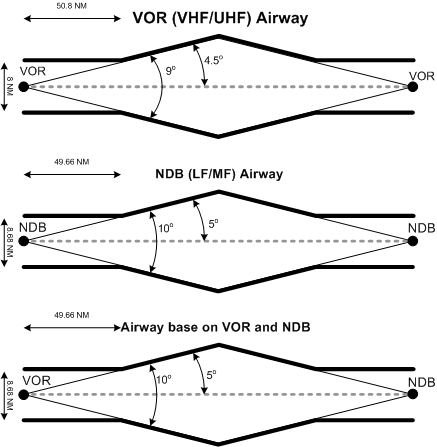
Airways between VORs/VORTACs are referred to as Victor Airways (V21 for example). They have a minimum width of 4 NM on either side of the fix, which expand, or are “splayed” by 4.5° from the centre line. After a distance of 50.8 NM from the fix, the splay begins to increase the width of the airway.
Airways between NDBs have the same base and ceiling, but their minimum width is 4.34 NM either side of the beacon, and splay by 5° from the centre line. After a distance of 49.66 NM from a NDB, the splay begins to increase the width of the airway.
Airways based on a combination of NDB and VOR/VORTAC navigation aids have the same dimensions as NDB-only airways.
Control Zones
Control Zones surround specified airports indicated on charts that have a control tower. They usually have a 7 NM (nautical mile) radius and extend from the surface to 3000’ AAE (above aerodrome elevation). The may be designated Class B, C, D or E airspace. Control Zones are the only form of controlled airspace that extend to the ground.
Mountainous Areas
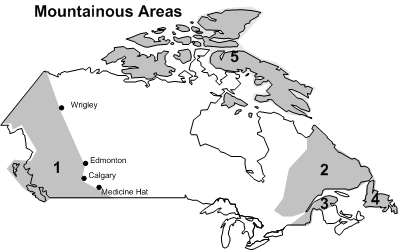
There are five Mountainous Areas in Canada as depicted above. They are specifically defined in the Designated Airspace Handbook.
Except where provided by specified minimum IFR altitudes published on charts and IFR approach and departure plates (e.g., minimum vectoring attitudes, MOCAs, transition altitudes, 100 NM safe altitudes, MSAs, and AMAs),5 an aircraft operating IFR in Mountainous Areas 1 and 5 must maintain a minimum altitude of 2000’ above the highest obstacle within a 5 NM radius. In all other Mountainous Areas, the minimum altitude is 1500’ above the highest obstacle within 5 NM.
Owing to temperature and pressure-induced errors in the indicated altimeter, when tracking airways in mountainous areas, IFR aircraft should operate at least 1000’ above the published airway altitude when there are large variations in temperature and/or temperature.6
References:
1 Defined on charts.
2 The 700’ base can be remembered here as the word “transit” has 7 letters—thank Henry Methorst for that one.
3 A third condition for Class F IFR operations, not discussed here, concerns an Altitude Reservation Approval. See AIP RAC 2.8.6 for information on this.
4 These are two types of approach clearances issued to an IFR aircraft for the purpose of conducting an approach using visual reference to ground. When the clearances are issued, the pilot can deviate from published instrument procedures.
5 These will be review later in the course in reference to minimum IFR altitudes.
6 See AIM RAC 8.5)