.jpg)


INSTRUMENT NAVIGATION
- INSTRUMENT NAVIGATION
IFR Navigation Charts
There are three types of IFR Charts: 1) Terminal Charts, which provide radio navigation data for some of the busier airports (quite similar to VTAs; 2) Enroute Low Altitude Charts, which provide radio navigation data for the en route portion of flights, up to, but not including 18000’ ASL, and, 3) Enroute High Altitude Charts, which provide similar data for the airspace at FL180 and above.
LE Charts are Lambert Conformal Conic Projection charts, and are similar to VNC Charts in that a straight line on an LE represent a great circle route.
Communication
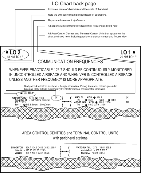
On back page of the LE are two blocks of information, the first concerning the VHF frequencies assigned to each of the major airports on the chart with control towers (including ATIS, Tower and Ground frequencies), and the second concerning the Area Control Centre and Terminal Control VHF frequencies, including peripheral station radio frequencies.
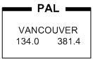
On the chart itself, the name of the applicable Area Control Centre, as well as the PAL frequencies, are identified using a boxed format. The PAL box on the right shows that Vancouver Centre can be contacted on 134.0 MHz., as well 381.4 MHz. (UHF).
Scale
The scale of the LE Charts vary—in the above example, for instance, the upper left and right corners of the back page show that LO 2 provides a scale of 18 NM per 1”, while LO 1is scaled at 20 NM to 1”. This variation in scale, however, is of little consequence, since all distances along airways between navigation aids and between intersections are published on the chart. In the case that a measurement is required—for example between a navigation aid and an airport—a scale bar that appears at the top and bottom of the chart can be used. Simply mark the distance on the edge of a scrap piece of paper and then position the paper next to the scale to read the distance.
Airspace
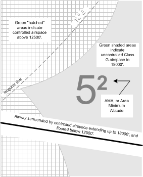
Note carefully the Legend that appears on LE charts. On the bottom right-hand corner of the Legend—under Miscellaneous—we are told that all green-shaded areas of the Chart indicate uncontrolled airspace below 18000’ ASL, while the white areas indicate controlled airspace below this altitude, including Low Level Airways, and Transition Areas. The Chart further delineates areas where controlled airspace exists above 12500’ ASL (Low Level Airways and Control Area Extensions)—all green areas patterned with white square (with green shade) hatching. Finally, note under this section is the description of isogonic lines (darker green and dashed). Note also the Area Minimum Altitudes (AMAs), which provides 2000’ clearance over the obstacle within the quadrantal (established by degrees longitude and latitude).
MOCA and MEA
Perhaps the most important information on the LE for the IFR pilot is the MOCA (Minimum Obstruction Clearance Altitudes), which is marked with an asterisk, and MEA (Minimum En Route Altitudes), which lack an asterisk (see depiction below).
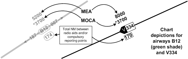
The MOCA provides an altitude above sea level in effect between radio fixes on low level airways or air routes that meet the IFR obstruction clearance requirement for the route segment.1 Importantly, the IFR obstruction clearance requirement varies with whether or not an airway or air route is located inside or outside a Designated Mountainous Area (DMA). Outside the DMAs, the MOCA provides 1000’ clearance over the highest obstacle within 5 NM of the aircraft; inside DMAs 2, 3, and 4, this clearance increases to 1500’, and in DMAs 1 and 5 this clearance increases to 2000’.
In contrast, the MEA provides an altitude above sea level between specified fixes on airways or air routes that assures acceptable navigational coverage, and which meets the IFR obstruction clearance requirements.2 Accordingly, MEA will always be higher than MOCA.
Also note that VHF/UHF airways are depicted in black ink, while LF/MF airways are in green. You will not have difficulty determining the proper odd/even altitude to fly as the even altitude direction associated with an airway is indicated by the pointed end of the airway identification box.
The following show the relationship between MEA and MOCA as they are applied to airway segments:
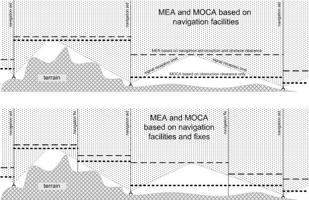
Note that each of the fixes depicted above will actually appear as an intersection on the LE chart, including the means by which the intersection is determined—i.e., DME, a radial or bearing from a neighbouring radio aid.
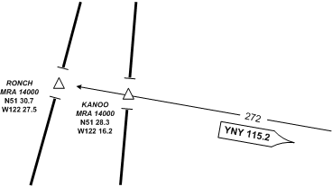
Minimum Reception Altitude
The Minimum Reception Altitude (MRA) should not get confused with the MOCA and the MEA. While the latter provides obstruction clearance data, the MRA only provides reception altitude guidance for published intersections. Specifically, the MRA is provided for specific VHF/UHF intersections and specifies the lowest altitude above sea level at which acceptable navigational signal coverage is received to determine the intersection.
Two intersections are depicted below—Ronch and Kanoo Intersections. They share the same MRA (14000’ ASL). Note that the co-ordinates for the intersections are provided, as is the radial, identifier, and frequency for the VOR used to establish the positions.
Radio Aids, Distance and Course Data
All radio Aids—i.e., NDB, VOR, VORTAC—are orientated to magnetic north in the Southern Domestic Airspace, and true north in the Northern Domestic Airspace. While the azimuths are correctly positioned, other navigation aid symbols may be positioned for sake of clarity.
The radio aid, distance and course data for the airway V112 between Calgary VORTAC and Cranbrook VOR is examined in detail below. Note that the actual distances between symbols are only approximated for the sake of clarity.
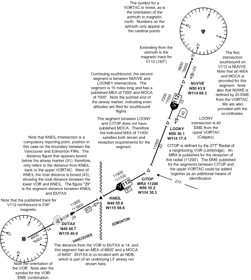
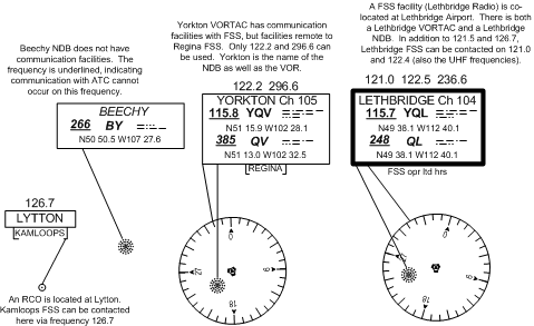
Navigation and Communication Data Boxes
The radio aid data boxes are virtually identical to the pattern used on VFR charts. A heavy line around the navigation aid data box indicates the facility is co-located with FSS. In the case a thin-lined box, FSS is not co-located with the facility. Remote FSS communication equipment is established at many radio aid sites, and these are indicated by the appearance of a sub-box below the navigation aid data box.
Standard frequencies—126.7, 121.5, and 243 MHz—are available for contacting FSS where FSS is co-located at the radio aid facility (heavy lined data boxes), unless otherwise noted. Additional frequencies used by FSS will be published above the data box, but note that the standard frequencies will not appear here—instead, it is implied that they are usable. If any of the standard frequencies are not available, they will be shown with a line through them. Note that the standard frequencies do not apply to thin-lined data boxes showing remote FSS communication; in these cases, only the frequencies published above the data boxes can be used.
Below appear three varieties.
Airport Data
The Aerodrome and Aerodrome Data depiction on IFR charts are conventional, and do not vary substantially for VFR chart references. Importantly, however, airports with published instrument approach procedures are displayed in black ink.
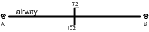
Changeover Points
Normally the radio aid used for tracking an airway is changed between the anchoring facilities at the half-way mark. Where this changeover point is different, it is marked as indicated below.. En route from VOR A to VOR B, the VOR A is selected until the 102-NM mark is reached, and then VOR B is selected.
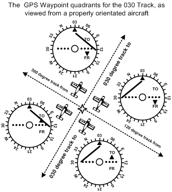
ADF, VOR, and GPS Navigation Procedures
Homing and Tracking
To “home” to a VOR station or GPS waypoint:
- tune and identify the VOR station or GPS waypoint;
- centre the CDI with OBS that provides a “to” indication;
- fly a heading to maintain the track—if the CDI migrates left, you are to the right of track; if the CDI migrates right, you are to the left of track.
To intercept a pre-determined track using VOR or GPS waypoint:
- tune and identify the VOR station or GPS waypoint;
- select the track desired using the OBS;
- orient the aircraft so that the desired track to or from the VOR or GPS waypoint is the same as the aircraft’s heading (paralleling the track);
- note whether the VOR or GPS waypoint is ahead of the lateral axis of the aircraft (indicated by a “to” indication), or behind the lateral axis (indicated by a “from” indication);
- if the CDI is on the right of centre, add the desired intercept angle to the current orientated heading and fly the intercept; if the CDI is on left, subtract the desired intercept angle;
- when the CDI centres during the intercept, alter course to maintain the desired track.
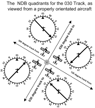
To “home” to a station using ADF:
- tune, identify, and test the NDB;3
- note the relative bearing to the NDB and turn the aircraft so that the relative bearing is 360° (i.e., the magnetic heading of the aircraft equals the magnetic bearing to the NDB);
- fly to maintain a relative bearing of 360°.
To intercept a pre-determined track using ADF:
- tune, identify, and test the NDB;
- orient the aircraft so that the desired track to or from the NDB is the same as the aircraft’s heading (paralleling the track);
- note whether the bearing indicator (the needle) is indicating right or left of the longitudinal axis of the aircraft;
- if the bearing indicator points to the right of longitudinal axis, add the desired intercept angle to the current orientated heading and fly the intercept; if the bearing indicator points to the right of longitudinal axis, subtract the desired intercept angle;4
- if you are intercepting a track from the NDB, you slowly “pull the tail” of the bearing indicator to match the intercept angle—when the tail “opens” to match your intercept angle, you are “on track” and should now turn on course; if you are intercepting a track to the NDB, you slowly “push the head” of the bearing indictor to match the intercept angle—when the tail “opens” to match the intercept angle, again you are “on track” and should now turn on course.5
The intercept angles used are the same (unless otherwise prescribed): a 45° angle is used when intercepting a track from a station (radio navigation aid), and a 90° angle is used when intercepting a track to a station.
Orientation—Paralleling the Track
The key to intercepting a desired track is first paralleling the track. When you get comfortable with interceptions, you will start skipping this phase, but until you get proficient at it, always parallel the track before you intercept it. By paralleling the track, you are effectively orienting yourself and the aircraft to the ground transmitter or waypoint. Is it located in front of or behind the aircraft? Is it located to the left or to the right? With a VOR or GPS waypoint, once the track is paralleled, the information derived from the instrument display can be directly applied to your mental picture of your location—you are looking for the “To” or “From” indication to determine if it is ahead or behind, and you look for the needle deflection to determine if it is right or left. Consider the depiction below:
![]()
Navigation Formula
Relative Bearing
Magnetic bearing, sometimes simply referred to as bearing, denotes the horizontal magnetic direction to or from any point. If the magnetic bearing (or bearing) to a station is 270°, for example, this means that we are directly east of the station; similarly, if our bearing to a station is 180°, we are directly north.
Relative bearing is the position of an object relative to the longitudinal axis of the aircraft. If an object lies directly off the right wing of an aircraft, it would be considered to be at a relative bearing of 090°. If the aircraft is eastbound and an object is directly to the north of the aircraft, the object still remains at a relative bearing of 270°, even though the magnetic bearing is 360°.
An aircraft is flying on a magnetic heading of 270°. An ADF indicator shows a relative bearing to a local NDB as 010°. To proceed directly to the NDB, what magnetic heading would be flown?
Here is the formula to be used:
Magnetic Bearing = Magnetic Heading + Relative Bearing6
or, MB = MH + RB
MB = 270 + 010
MB = 280
To fly to the NDB (or beacon), the pilot would fly 280°.
Now, what would happen if the magnetic heading and relative bearing, added together, equalled a value greater than 360. The solution is straightforward—simply take the sum and subtract 360. For example, an aircraft is flying a heading of 270° and the relative bearing to the station is 180°. What magnetic bearing should the pilot fly to proceed directly to the station?
MB = MH + RB
MB = 270 + 180
MB = 450
MB = (450 – 360)
MB = 090
To fly to the NDB (or beacon), the pilot would fly 090°.
A similar variation on the formula can be encountered when determining the relative bearing. To establish relative bearing by itself on one side of the equation, simply subtract MH from both sides:
MB = MH + RB
MB - MH = (MH + RB) - MH
MB - MH = RB or,
RB = MB - MH
On occasion you will find that the magnetic bearing is greater than the aircraft’s magnetic heading. A negative answer will not do, of course, but the solution is quite straight forward—simply add 360° to the magnetic bearing. Here is an example: The aircraft’s magnetic heading is 270° and the magnetic bearing to an NDB is 180°. What is the relative bearing to the NDB?
RB = MB - MH
RB = 180 - 270
RB = (180 + 360) - 270
RB = 540 - 270
RB = 270
So, let’s see if this makes sense. The aircraft is flying westbound (i.e., from right to left across your piece of paper). The magnetic bearing to the station is 180°, so that would put the station below the aircraft at the bottom of the page (i.e., the south). What would be the relative bearing of this station with respect to the nose of the aircraft—yes, it would be directly off the left wing, or 270° measured clockwise from the aircraft’s longitudinal axis!
Time and Distance to Station
There are two formulas to be aware of which allow a pilot to determine the time or distance to an NDB or VOR station. To use the formula, the pilot must first be tracking directly to the station in question; then the aircraft is turned 90° from that heading to a perpendicular track. The pilot then notes the changes in the bearing to the station and the amount of time required produce the bearing change.
The two equations are as follows:
|
Time to Station (minutes) |
= |
Time (seconds) required for degrees or radials change Number of degrees/radials changed |
|
Distance to Station (NM) |
= |
TAS x Time to station in (minutes) 60 |
Applying these formulas to VORs, for example, let us assume that an aircraft is tracking inbound on the 270° Radial of a VOR. The pilot wishes to know the aircraft’s distance from the VOR station. To do this, the pilot then turns the aircraft to a heading of 360°, and starts timing. After two minutes the pilot notes that the CDI has deflected 1 ½ dots—or what is three degrees. Here comes the math:
|
Time to Station (minutes) |
= |
120 3 |
|
Time to Station (minutes) |
= |
40 |
The aircraft is 40 minutes from the VOR.
Assuming that the aircraft travels at 120 KTS TAS, the pilot then wishes to estimate the distance of the aircraft from the VOR. Here we go:
|
Distance to Station (NM) |
= |
120 x 40 60 |
||||
|
Distance to Station (NM) |
= |
80 |
||
The aircraft is 80 NM from the VOR.
Now let us apply these formulas to use of NDBs. Again, the aircraft is tracking directly to an NDB and the pilot wishes to determine the exact time and distance required for station passage. Using a fixed card ADF the pilot turns 90° from the course and notes that it takes 2 minutes for the relative bearing to the NDB to change from 270° to 262°. Again, here comes the math: 120 seconds divided by 8 equals 15—the aircraft is therefore 15 minutes from the NDB. If the TAS of the aircraft is 150 KTS, 150 is multiplied by 15 to equal 2250, and 2250 is divided by 60 to equal 37.5—the aircraft is therefore 37.5 NM from the NDB.
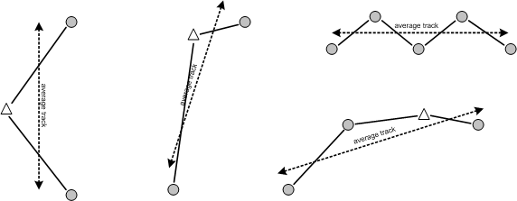
Track Measurement
Whenever it is required to produce a quick measurement of estimated en route along an airway with a dogleg, or a series of airways with different tracks, an effective way to do this is to “eyeball-estimate” an average track. When the average track is determined, the forecast winds can be applied to determine the average groundspeed, and the total distance of the actual routing can be applied to the average groundspeed to determine the total time en route.
Here are some examples of average tracks:
References:
1 AIM GEN 5.1 (Glossary of Aeronautical Terms)
2 Ibid.
3 Unlike a VOR, the NDB signal is tested every time a new NDB is selected. If the ADF is equipped with a “test” button, this is pressed and the bearing indicator will move to the 090° relative bearing position; if the ADF does not have a test feature, move the function selector switch from the ADF position to the ANT position (the ANT position removes the directional “loop antenna” from the system, allowing only the non-directional “sense antenna” to receive the signal), and again the 090° relative bearing will be received.
4 In fact, you do not add or subtract, but instead simply glance at the ADF rotating card and read the intercept heading—presuming, of course that you have “bugged” the orientation heading. In the event of a fixed card ADF, simply transpose the bearing indication onto the heading indicator; as you turn to the intercept heading, you should see the desired track under either the 45° or 90° marker on the heading indicator.
5 This is quite tricky business and you should spend time on the ground reviewing this “tail pulling” and “head pushing” on a scrap of paper—but of course it is best seen in the air.
6 “Mary Barfed after Mary Had Roast Beef” or “Mary Had Roast Beef—Mary Barfed.” Thanks to Gerry Unger for this.